Jeremoabo elevation
Jeremoabo (Bahia), Brazil elevation is 334 meters and Jeremoabo elevation in feet is 1096 ft above sea level [src 1]. Jeremoabo is a populated place (feature code) with elevation that is 48 meters (157 ft) smaller than average city elevation in Brazil.
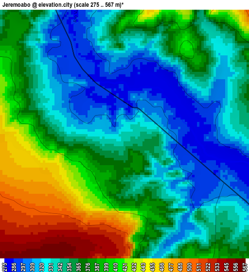
Below is the Elevation map of Jeremoabo, which displays elevation range with different colors. Scale of the first map is from 275 to 567 m (902 to 1860 ft) with average elevation of 368.3 meters (=1208 ft) [note 1]
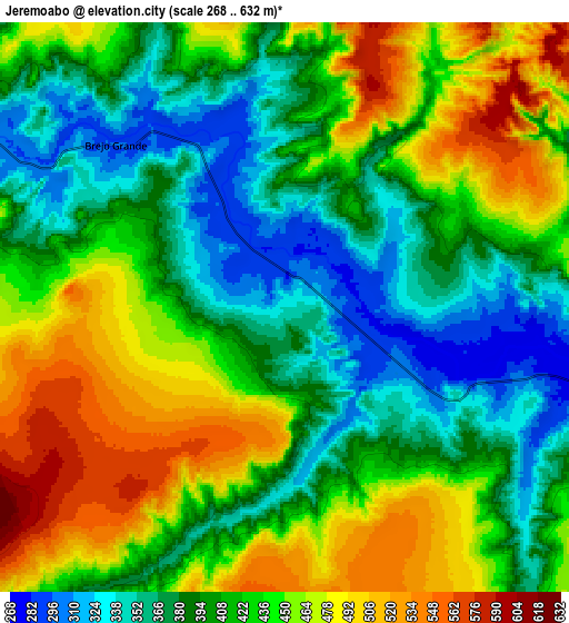
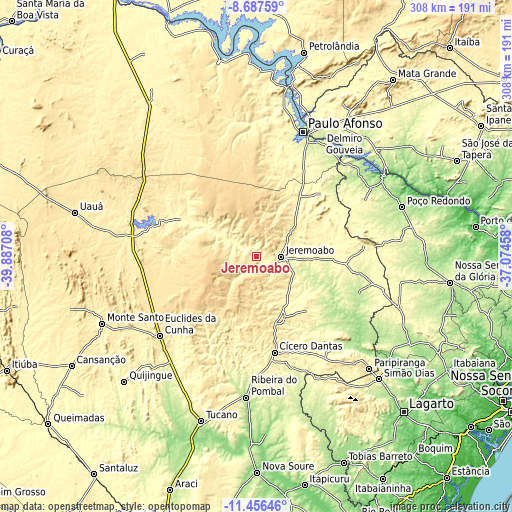
These maps also provides idea of topography and contour of this city, they are displayed at different zoom levels. More info about maps, scale and edge coordinates you can find below images.
| \ | Map #1 | Map #2 | Topo.Map |
| Scale [m] | 275..567 m | 268..632 m | × |
| Scale [ft] | 902..1860 ft | 879..2073 ft | × |
| Average | 368.3 m = 1208 ft | 420.4 m = 1379 ft | × |
| Width | 9.62 km = 6 mi | 19.24 km = 12 mi | 307.9 km = 191.3 mi |
| Height | 9.62 km = 6 mi | 19.24 km = 12 mi | 307.9 km = 191.3 mi |
| ↑Max Latitude | -10.031729° | -9.988453° | -8.68759° |
| Latitude at center | -10.075° | -10.075° | -10.075° |
| ↓Min Latitude | -10.118265° | -10.161524° | -11.45646° |
| ← Min Longitude | -38.524775° | -38.568721° | -39.88708° |
| Longitude center | -38.48083° | -38.48083° | -38.48083° |
| →Max Longitude | -38.436885° | -38.392939° | -37.07458° |
Nearby cities:
Cities around Jeremoabo sort by population:
• Paulo Afonso elevation 245 m
79.9 km,  21°
21°
• Delmiro Gouveia 246 m
92.8 km,  34°
34°
• Euclides da Cunha 478 m
75.8 km,  230°
230°
• Ribeira do Pombal 221 m
84.7 km,  184°
184°
• Jatobá 286 m
101.9 km,  13°
13°
• Cícero Dantas 399 m
59.3 km,  169°
169°
• Poço Verde 260 m
77.6 km,  155°
155°
• Canindé de São Francisco 179 m
88.7 km,  58°
58°
• Carira 361 m
91 km,  110°
110°
• Monte Santo 483 m
101.6 km,  246°
246°
• Paripiranga 439 m
96 km,  135°
135°
• Monte Alegre de Sergipe 262 m
100.7 km,  86°
86°
Multilingual:
 En español:
Jeremoabo elevación 334 m.
 En France:
Jeremoabo élévation 334 m.
 Auf Deutsch:
Jeremoabo höhe über dem Meeresspiegel ist 334 m.

Sources and notes:
- [note 1] Map square and city borders are not equal. Map elevation data is calculated only from area inside that square.
- [src 1] Elevation data from geonames database provided with same terms of usage.
- [src 2] The elevation map of Jeremoabo is generated using elevation data from NASA's 3 arcsec (90m) resolution SRTM data.
- [src 3] Base (background) map © OpenStreetMap contributors tiles are generated by Geofabrik and OpenTopoMap.
Copyright & License:
This Jeremoabo Elevation Map is licensed under CC BY-SA. You may reuse any part from this page, if you give a proper credit by linking to this URL:
 More info on terms of use page.