Monte Santo elevation
Monte Santo (Bahia), Brazil elevation is 483 meters and Monte Santo elevation in feet is 1585 ft above sea level [src 1]. Monte Santo is a populated place (feature code) with elevation that is 101 meters (331 ft) bigger than average city elevation in Brazil.
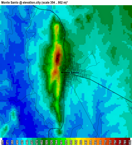
Below is the Elevation map of Monte Santo, which displays elevation range with different colors. Scale of the first map is from 354 to 802 m (1161 to 2631 ft) with average elevation of 439.3 meters (=1441 ft) [note 1]
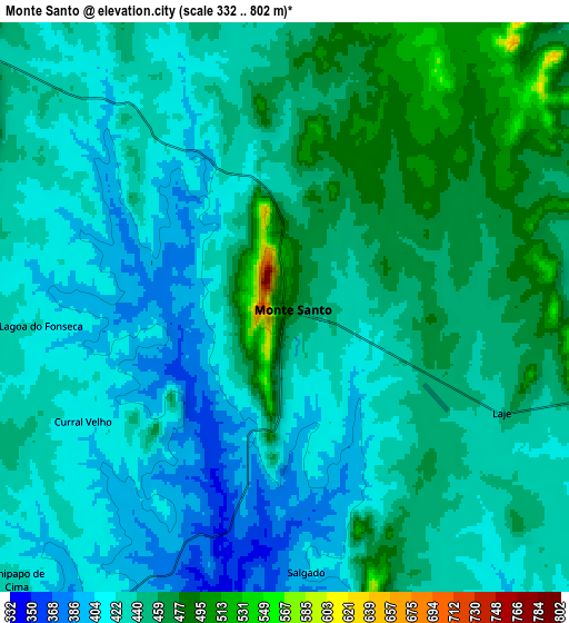
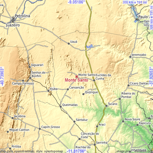
These maps also provides idea of topography and contour of this city, they are displayed at different zoom levels. More info about maps, scale and edge coordinates you can find below images.
| \ | Map #1 | Map #2 | Topo.Map |
| Scale [m] | 354..802 m | 332..802 m | × |
| Scale [ft] | 1161..2631 ft | 1089..2631 ft | × |
| Average | 439.3 m = 1441 ft | 437.4 m = 1435 ft | × |
| Width | 9.61 km = 6 mi | 19.22 km = 11.9 mi | 307.5 km = 191.1 mi |
| Height | 9.61 km = 6 mi | 19.22 km = 11.9 mi | 307.5 km = 191.1 mi |
| ↑Max Latitude | -10.394559° | -10.351332° | -9.05186° |
| Latitude at center | -10.43778° | -10.43778° | -10.43778° |
| ↓Min Latitude | -10.480995° | -10.524204° | -11.81756° |
| ← Min Longitude | -39.376725° | -39.420671° | -40.73903° |
| Longitude center | -39.33278° | -39.33278° | -39.33278° |
| →Max Longitude | -39.288835° | -39.244889° | -37.92653° |
Nearby cities:
Cities around Monte Santo sort by population:
• Senhor do Bonfim elevation 544 m
93.7 km,  268°
268°
• Tucano 222 m
82.8 km,  134°
134°
• Euclides da Cunha 478 m
35.5 km,  102°
102°
• Ribeira do Pombal 221 m
97.6 km,  116°
116°
• Santaluz 361 m
91.1 km,  182°
182°
• Jaguarari 660 m
96.4 km,  281°
281°
• Cícero Dantas 399 m
105.4 km, 99°
• Jeremoabo 334 m
101.6 km,  66°
66°
• Uauá 440 m
68.3 km,  346°
346°
• Queimadas 291 m
68.1 km,  208°
208°
• Ponto Novo 370 m
99.5 km,  241°
241°
• Quijingue 358 m
37.5 km,  158°
158°
Multilingual:
 En español:
Monte Santo elevación 483 m.
 En France:
Monte Santo élévation 483 m.
 Auf Deutsch:
Monte Santo höhe über dem Meeresspiegel ist 483 m.

Sources and notes:
- [note 1] Map square and city borders are not equal. Map elevation data is calculated only from area inside that square.
- [src 1] Elevation data from geonames database provided with same terms of usage.
- [src 2] The elevation map of Monte Santo is generated using elevation data from NASA's 3 arcsec (90m) resolution SRTM data.
- [src 3] Base (background) map © OpenStreetMap contributors tiles are generated by Geofabrik and OpenTopoMap.
Copyright & License:
This Monte Santo Elevation Map is licensed under CC BY-SA. You may reuse any part from this page, if you give a proper credit by linking to this URL:
 More info on terms of use page.