Noetinger elevation
Noetinger (Cordoba, Departamento de Marcos Juárez), Argentina elevation is 113 meters and Noetinger elevation in feet is 371 ft above sea level [src 1]. Noetinger is a populated place (feature code) with elevation that is 237 meters (778 ft) smaller than average city elevation in Argentina.
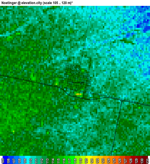
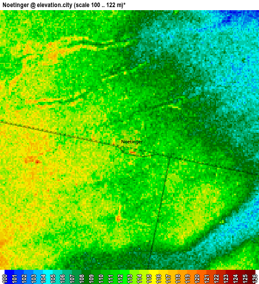
Below is the Elevation map of Noetinger, which displays elevation range with different colors. Scale of the first map is from 105 to 120 m (344 to 394 ft) with average elevation of 111.7 meters (=366 ft) [note 1]
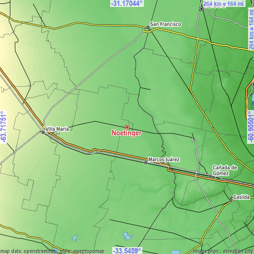
These maps also provides idea of topography and contour of this city, they are displayed at different zoom levels. More info about maps, scale and edge coordinates you can find below images.
| \ | Map #1 | Map #2 | Topo.Map |
| Scale [m] | 105..120 m | 100..122 m | × |
| Scale [ft] | 344..394 ft | 328..400 ft | × |
| Average | 111.7 m = 366 ft | 110.7 m = 363 ft | × |
| Width | 8.25 km = 5.1 mi | 16.51 km = 10.3 mi | 264.1 km = 164.1 mi |
| Height | 8.25 km = 5.1 mi | 16.51 km = 10.3 mi | 264.1 km = 164.1 mi |
| ↑Max Latitude | -32.328844° | -32.291703° | -31.17044° |
| Latitude at center | -32.36597° | -32.36597° | -32.36597° |
| ↓Min Latitude | -32.403081° | -32.440176° | -33.5459° |
| ← Min Longitude | -62.355205° | -62.399151° | -63.71751° |
| Longitude center | -62.31126° | -62.31126° | -62.31126° |
| →Max Longitude | -62.267315° | -62.223369° | -60.90501° |
Nearby cities:
Cities around Noetinger sort by population:
• Bell Ville elevation 132 m
45.7 km,  230°
230°
• Marcos Juárez 117 m
41.6 km,  152°
152°
• Las Varillas 138 m
67 km,  325°
325°
• El Trébol 96 m
60.2 km,  72°
72°
• Leones 120 m
32.9 km,  177°
177°
• Justiniano Posse 120 m
67.1 km,  210°
210°
• Monte Buey 113 m
62.7 km,  192°
192°
• Inriville 108 m
64.7 km,  173°
173°
• Morrison 148 m
55.3 km,  242°
242°
• General Roca 90 m
55 km,  137°
137°
• San Antonio de Litín 130 m
34.6 km,  299°
299°
• Cintra 130 m
32.7 km,  281°
281°
Multilingual:
 En español:
Noetinger elevación 113 m.
 En France:
Noetinger élévation 113 m.
 Auf Deutsch:
Noetinger höhe über dem Meeresspiegel ist 113 m.

Sources and notes:
- [note 1] Map square and city borders are not equal. Map elevation data is calculated only from area inside that square.
- [src 1] Elevation data from geonames database provided with same terms of usage.
- [src 2] The elevation map of Noetinger is generated using elevation data from NASA's 3 arcsec (90m) resolution SRTM data.
- [src 3] Base (background) map © OpenStreetMap contributors tiles are generated by Geofabrik and OpenTopoMap.
Copyright & License:
This Noetinger Elevation Map is licensed under CC BY-SA. You may reuse any part from this page, if you give a proper credit by linking to this URL:
 More info on terms of use page.