Marcos Juárez elevation
Marcos Juárez (Cordoba, Departamento de Marcos Juárez), Argentina elevation is 117 meters and Marcos Juárez elevation in feet is 384 ft above sea level [src 1]. Marcos Juárez is a seat of a second-order administrative division (feature code) with elevation that is 233 meters (764 ft) smaller than average city elevation in Argentina.
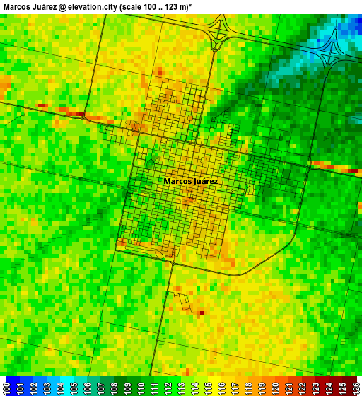
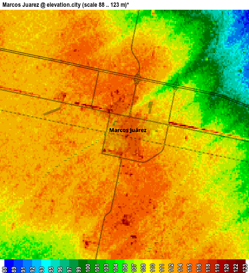
Below is the Elevation map of Marcos Juárez, which displays elevation range with different colors. Scale of the first map is from 100 to 123 m (328 to 404 ft) with average elevation of 112.8 meters (=370 ft) [note 1]
These maps also provides idea of topography and contour of this city, they are displayed at different zoom levels. More info about maps, scale and edge coordinates you can find below images.
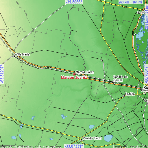
| \ | Map #1 | Map #2 | Topo.Map |
| Scale [m] | 100..123 m | 88..123 m | × |
| Scale [ft] | 328..404 ft | 289..404 ft | × |
| Average | 112.8 m = 370 ft | 110.1 m = 361 ft | × |
| Width | 8.22 km = 5.1 mi | 16.45 km = 10.2 mi | 263.2 km = 163.5 mi |
| Height | 8.22 km = 5.1 mi | 16.45 km = 10.2 mi | 263.2 km = 163.5 mi |
| ↑Max Latitude | -32.660811° | -32.623807° | -31.5066° |
| Latitude at center | -32.6978° | -32.6978° | -32.6978° |
| ↓Min Latitude | -32.734774° | -32.771732° | -33.87331° |
| ← Min Longitude | -62.150665° | -62.194611° | -63.51297° |
| Longitude center | -62.10672° | -62.10672° | -62.10672° |
| →Max Longitude | -62.062775° | -62.018829° | -60.70047° |
Nearby cities:
Cities around Marcos Juárez sort by population:
• Bell Ville elevation 132 m
55.1 km,  278°
278°
• Las Rosas 107 m
55.1 km,  63°
63°
• Armstrong 122 m
48.1 km,  101°
101°
• Leones 120 m
18.2 km, 282°
• Cruz Alta 78 m
44.5 km,  141°
141°
• Monte Buey 113 m
40.8 km,  233°
233°
• Camilo Aldao 113 m
47.8 km,  178°
178°
• Noetinger 113 m
41.6 km,  332°
332°
• Inriville 108 m
29.7 km,  202°
202°
• Los Surgentes 101 m
32.9 km,  166°
166°
• General Roca 90 m
18.2 km, 102°
• General Baldissera 112 m
50.8 km, 201°
Multilingual:
 En español:
Marcos Juárez elevación 117 m.
 En France:
Marcos Juárez élévation 117 m.
 Auf Deutsch:
Marcos Juárez höhe über dem Meeresspiegel ist 117 m.

Sources and notes:
- [note 1] Map square and city borders are not equal. Map elevation data is calculated only from area inside that square.
- [src 1] Elevation data from geonames database provided with same terms of usage.
- [src 2] The elevation map of Marcos Juárez is generated using elevation data from NASA's 3 arcsec (90m) resolution SRTM data.
- [src 3] Base (background) map © OpenStreetMap contributors tiles are generated by Geofabrik and OpenTopoMap.
Copyright & License:
This Marcos Juárez Elevation Map is licensed under CC BY-SA. You may reuse any part from this page, if you give a proper credit by linking to this URL:
 More info on terms of use page.