Las Varillas elevation
Las Varillas (Cordoba, Departamento de San Justo), Argentina elevation is 138 meters and Las Varillas elevation in feet is 453 ft above sea level [src 1]. Las Varillas is a populated place (feature code) with elevation that is 212 meters (696 ft) smaller than average city elevation in Argentina.
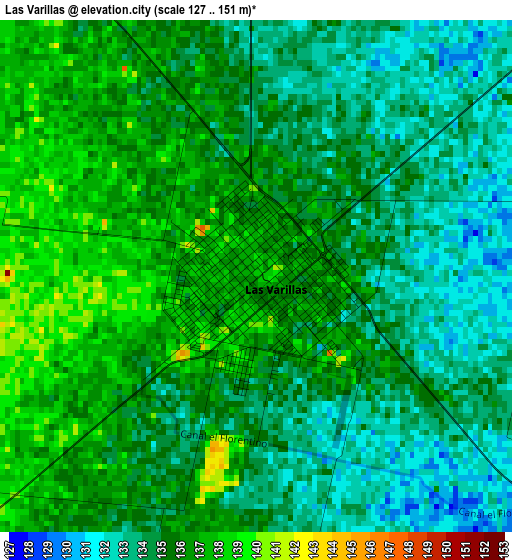
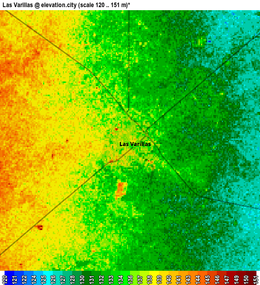
Below is the Elevation map of Las Varillas, which displays elevation range with different colors. Scale of the first map is from 127 to 151 m (417 to 495 ft) with average elevation of 134.9 meters (=443 ft) [note 1]
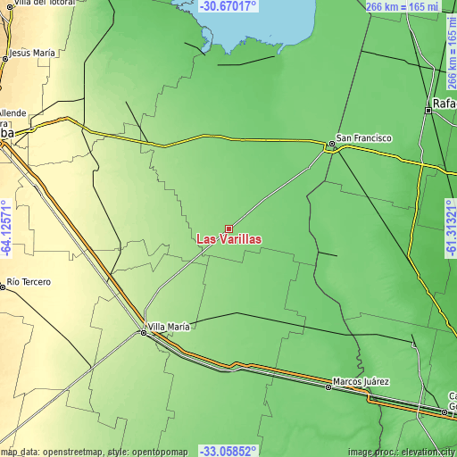
These maps also provides idea of topography and contour of this city, they are displayed at different zoom levels. More info about maps, scale and edge coordinates you can find below images.
| \ | Map #1 | Map #2 | Topo.Map |
| Scale [m] | 127..151 m | 120..151 m | × |
| Scale [ft] | 417..495 ft | 394..495 ft | × |
| Average | 134.9 m = 443 ft | 134.3 m = 441 ft | × |
| Width | 8.3 km = 5.2 mi | 16.6 km = 10.3 mi | 265.6 km = 165 mi |
| Height | 8.3 km = 5.2 mi | 16.6 km = 10.3 mi | 265.6 km = 165 mi |
| ↑Max Latitude | -31.834753° | -31.797411° | -30.67017° |
| Latitude at center | -31.87208° | -31.87208° | -31.87208° |
| ↓Min Latitude | -31.909392° | -31.946689° | -33.05852° |
| ← Min Longitude | -62.763405° | -62.807351° | -64.12571° |
| Longitude center | -62.71946° | -62.71946° | -62.71946° |
| →Max Longitude | -62.675515° | -62.631569° | -61.31321° |
Nearby cities:
Cities around Las Varillas sort by population:
• Pozo del Molle elevation 160 m
25 km,  229°
229°
• La Francia 112 m
52.4 km,  8°
8°
• Sacanta 166 m
38.6 km,  307°
307°
• La Playosa 175 m
38.8 km, 229°
• Saturnino M. Laspiur 114 m
29.3 km,  50°
50°
• Carrilobo 185 m
37.6 km,  269°
269°
• El Tío 126 m
55.3 km,  349°
349°
• El Arañado 150 m
21.9 km, 311°
• San Antonio de Litín 130 m
38.9 km,  167°
167°
• Colonia San Bartolomé 125 m
38.3 km,  359°
359°
• Cintra 130 m
48.7 km, 172°
• Las Varas 128 m
12.4 km, 51°
Multilingual:
 En español:
Las Varillas elevación 138 m.
 En France:
Las Varillas élévation 138 m.
 Auf Deutsch:
Las Varillas höhe über dem Meeresspiegel ist 138 m.

Sources and notes:
- [note 1] Map square and city borders are not equal. Map elevation data is calculated only from area inside that square.
- [src 1] Elevation data from geonames database provided with same terms of usage.
- [src 2] The elevation map of Las Varillas is generated using elevation data from NASA's 3 arcsec (90m) resolution SRTM data.
- [src 3] Base (background) map © OpenStreetMap contributors tiles are generated by Geofabrik and OpenTopoMap.
Copyright & License:
This Las Varillas Elevation Map is licensed under CC BY-SA. You may reuse any part from this page, if you give a proper credit by linking to this URL:
 More info on terms of use page.