Vicuña Mackenna elevation
Vicuña Mackenna (Cordoba, Departamento de Río Cuarto), Argentina elevation is 243 meters and Vicuña Mackenna elevation in feet is 797 ft above sea level [src 1]. Vicuña Mackenna is a populated place (feature code) with elevation that is 107 meters (351 ft) smaller than average city elevation in Argentina.
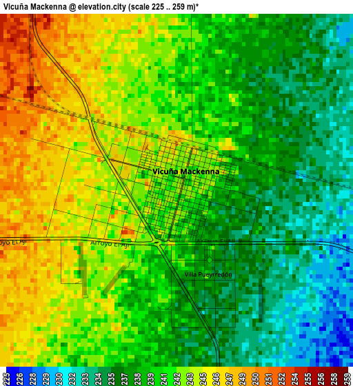
Below is the Elevation map of Vicuña Mackenna, which displays elevation range with different colors. Scale of the first map is from 225 to 259 m (738 to 850 ft) with average elevation of 240.4 meters (=789 ft) [note 1]
These maps also provides idea of topography and contour of this city, they are displayed at different zoom levels. More info about maps, scale and edge coordinates you can find below images.
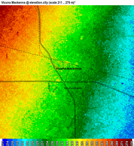
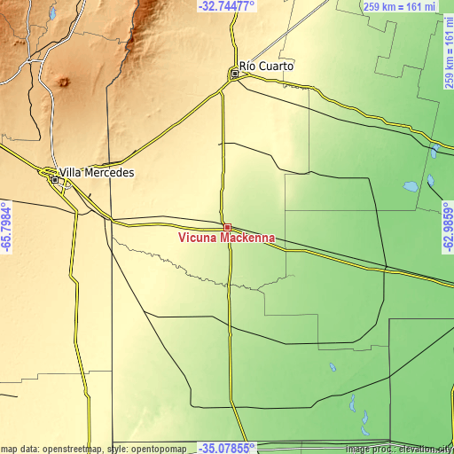
| \ | Map #1 | Map #2 | Topo.Map |
| Scale [m] | 225..259 m | 211..276 m | × |
| Scale [ft] | 738..850 ft | 692..906 ft | × |
| Average | 240.4 m = 789 ft | 240.3 m = 788 ft | × |
| Width | 8.11 km = 5 mi | 16.22 km = 10.1 mi | 259.5 km = 161.2 mi |
| Height | 8.11 km = 5 mi | 16.22 km = 10.1 mi | 259.5 km = 161.2 mi |
| ↑Max Latitude | -33.883175° | -33.846685° | -32.74477° |
| Latitude at center | -33.91965° | -33.91965° | -33.91965° |
| ↓Min Latitude | -33.956109° | -33.992552° | -35.07855° |
| ← Min Longitude | -64.436095° | -64.480041° | -65.7984° |
| Longitude center | -64.39215° | -64.39215° | -64.39215° |
| →Max Longitude | -64.348205° | -64.304259° | -62.9859° |
Nearby cities:
Cities around Vicuña Mackenna sort by population:
• Justo Daract elevation 421 m
73.3 km,  275°
275°
• Coronel Moldes 365 m
38.1 km,  330°
330°
• Sampacho 513 m
66.9 km, 332°
• Adelia María 266 m
46.9 km,  46°
46°
• General Levalle 180 m
44.4 km,  103°
103°
• Santa Magdalena 158 m
78.2 km,  148°
148°
• Del Campillo 228 m
51.7 km,  190°
190°
• San Basilio 303 m
47.5 km,  8°
8°
• Villa Valeria 297 m
67.5 km,  226°
226°
• Las Acequias 295 m
80.7 km,  28°
28°
• Mattaldi 181 m
65.7 km,  162°
162°
• Huanchillas 161 m
75.2 km,  68°
68°
Multilingual:
 En español:
Vicuña Mackenna elevación 243 m.
 En France:
Vicuña Mackenna élévation 243 m.
 Auf Deutsch:
Vicuña Mackenna höhe über dem Meeresspiegel ist 243 m.

Sources and notes:
- [note 1] Map square and city borders are not equal. Map elevation data is calculated only from area inside that square.
- [src 1] Elevation data from geonames database provided with same terms of usage.
- [src 2] The elevation map of Vicuña Mackenna is generated using elevation data from NASA's 3 arcsec (90m) resolution SRTM data.
- [src 3] Base (background) map © OpenStreetMap contributors tiles are generated by Geofabrik and OpenTopoMap.
Copyright & License:
This Vicuña Mackenna Elevation Map is licensed under CC BY-SA. You may reuse any part from this page, if you give a proper credit by linking to this URL:
 More info on terms of use page.