Sampacho elevation
Sampacho (Cordoba, Departamento de Río Cuarto), Argentina elevation is 513 meters and Sampacho elevation in feet is 1683 ft above sea level [src 1]. Sampacho is a populated place (feature code) with elevation that is 163 meters (535 ft) bigger than average city elevation in Argentina.
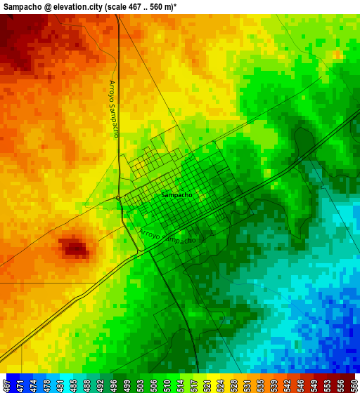
Below is the Elevation map of Sampacho, which displays elevation range with different colors. Scale of the first map is from 467 to 560 m (1532 to 1837 ft) with average elevation of 513.8 meters (=1686 ft) [note 1]
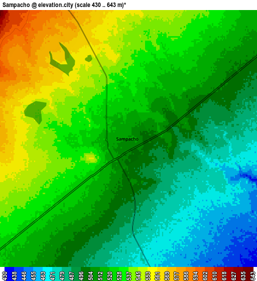
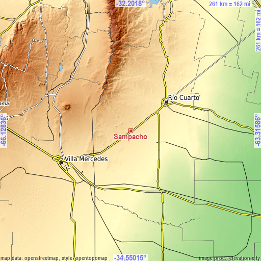
These maps also provides idea of topography and contour of this city, they are displayed at different zoom levels. More info about maps, scale and edge coordinates you can find below images.
| \ | Map #1 | Map #2 | Topo.Map |
| Scale [m] | 467..560 m | 430..643 m | × |
| Scale [ft] | 1532..1837 ft | 1411..2110 ft | × |
| Average | 513.8 m = 1686 ft | 516 m = 1693 ft | × |
| Width | 8.16 km = 5.1 mi | 16.32 km = 10.1 mi | 261.1 km = 162.2 mi |
| Height | 8.16 km = 5.1 mi | 16.32 km = 10.1 mi | 261.1 km = 162.2 mi |
| ↑Max Latitude | -33.347198° | -33.31048° | -32.2018° |
| Latitude at center | -33.3839° | -33.3839° | -33.3839° |
| ↓Min Latitude | -33.420587° | -33.457258° | -34.55015° |
| ← Min Longitude | -64.766055° | -64.810001° | -66.12836° |
| Longitude center | -64.72211° | -64.72211° | -64.72211° |
| →Max Longitude | -64.678165° | -64.634219° | -63.31586° |
Nearby cities:
Cities around Sampacho sort by population:
• Río Cuarto elevation 441 m
44.6 km,  50°
50°
• Villa Mercedes 516 m
75.5 km,  244°
244°
• Justo Daract 421 m
67.9 km,  218°
218°
• Vicuña Mackenna 243 m
66.9 km,  152°
152°
• Coronel Moldes 365 m
29 km,  156°
156°
• Adelia María 266 m
70.6 km,  112°
112°
• Las Higueras 432 m
51.7 km, 51°
• San Basilio 303 m
39.8 km, 108°
• Achiras 832 m
34.3 km,  312°
312°
• Las Acequias 295 m
70.2 km,  80°
80°
• Coronel Baigorria 532 m
68.4 km,  29°
29°
• Charras 350 m
74.5 km,  57°
57°
Multilingual:
 En español:
Sampacho elevación 513 m.
 En France:
Sampacho élévation 513 m.
 Auf Deutsch:
Sampacho höhe über dem Meeresspiegel ist 513 m.

Sources and notes:
- [note 1] Map square and city borders are not equal. Map elevation data is calculated only from area inside that square.
- [src 1] Elevation data from geonames database provided with same terms of usage.
- [src 2] The elevation map of Sampacho is generated using elevation data from NASA's 3 arcsec (90m) resolution SRTM data.
- [src 3] Base (background) map © OpenStreetMap contributors tiles are generated by Geofabrik and OpenTopoMap.
Copyright & License:
This Sampacho Elevation Map is licensed under CC BY-SA. You may reuse any part from this page, if you give a proper credit by linking to this URL:
 More info on terms of use page.