Coronel Baigorria elevation
Coronel Baigorria (Cordoba, Departamento de Río Cuarto), Argentina elevation is 532 meters and Coronel Baigorria elevation in feet is 1745 ft above sea level [src 1]. Coronel Baigorria is a populated place (feature code) with elevation that is 182 meters (597 ft) bigger than average city elevation in Argentina.
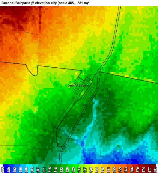
Below is the Elevation map of Coronel Baigorria, which displays elevation range with different colors. Scale of the first map is from 485 to 581 m (1591 to 1906 ft) with average elevation of 531.7 meters (=1744 ft) [note 1]
These maps also provides idea of topography and contour of this city, they are displayed at different zoom levels. More info about maps, scale and edge coordinates you can find below images.
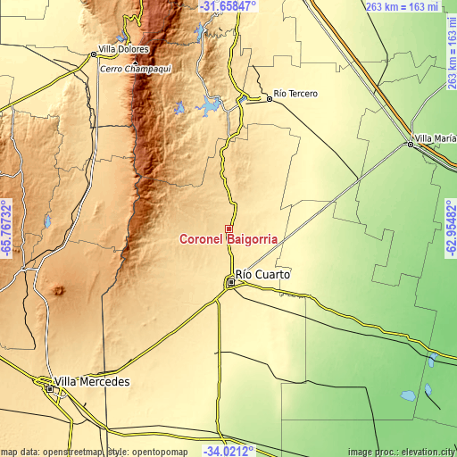
| \ | Map #1 | Topo.Map |
| Scale [m] | 485..581 m | × |
| Scale [ft] | 1591..1906 ft | × |
| Average | 531.7 m = 1744 ft | × |
| Width | 8.21 km = 5.1 mi | 262.7 km = 163.2 mi |
| Height | 8.21 km = 5.1 mi | 262.7 km = 163.2 mi |
| ↑Max Latitude | -32.810773° | -31.65847° |
| Latitude at center | -32.8477° | -32.8477° |
| ↓Min Latitude | -32.884611° | -34.0212° |
| ← Min Longitude | -64.405015° | -65.76732° |
| Longitude center | -64.36107° | -64.36107° |
| →Max Longitude | -64.317125° | -62.95482° |
Nearby cities:
Cities around Coronel Baigorria sort by population:
• Río Cuarto elevation 441 m
31.5 km,  178°
178°
• General Cabrera 298 m
45.8 km,  85°
85°
• Sampacho 513 m
68.4 km,  209°
209°
• Berrotarán 631 m
44.2 km,  356°
356°
• Las Higueras 432 m
28 km,  166°
166°
• Las Perdices 253 m
63.4 km,  74°
74°
• Elena 635 m
30.8 km,  354°
354°
• Los Cóndores 542 m
59.2 km,  7°
7°
• Las Acequias 295 m
60.1 km,  143°
143°
• Carnerillo 322 m
32.5 km,  103°
103°
• Villa Reducción 265 m
60.9 km,  130°
130°
• Charras 350 m
35.2 km,  123°
123°
Multilingual:
 En español:
Coronel Baigorria elevación 532 m.
 En France:
Coronel Baigorria élévation 532 m.
 Auf Deutsch:
Coronel Baigorria höhe über dem Meeresspiegel ist 532 m.

Sources and notes:
- [note 1] Map square and city borders are not equal. Map elevation data is calculated only from area inside that square.
- [src 1] Elevation data from geonames database provided with same terms of usage.
- [src 2] The elevation map of Coronel Baigorria is generated using elevation data from NASA's 3 arcsec (90m) resolution SRTM data.
- [src 3] Base (background) map © OpenStreetMap contributors tiles are generated by Geofabrik and OpenTopoMap.
Copyright & License:
This Coronel Baigorria Elevation Map is licensed under CC BY-SA. You may reuse any part from this page, if you give a proper credit by linking to this URL:
 More info on terms of use page.