Elena elevation
Elena (Cordoba, Departamento de Río Cuarto), Argentina elevation is 635 meters and Elena elevation in feet is 2083 ft above sea level [src 1]. Elena is a populated place (feature code) with elevation that is 285 meters (935 ft) bigger than average city elevation in Argentina.
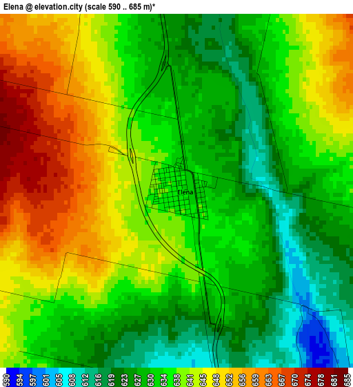
Below is the Elevation map of Elena, which displays elevation range with different colors. Scale of the first map is from 590 to 685 m (1936 to 2247 ft) with average elevation of 636.4 meters (=2088 ft) [note 1]
These maps also provides idea of topography and contour of this city, they are displayed at different zoom levels. More info about maps, scale and edge coordinates you can find below images.
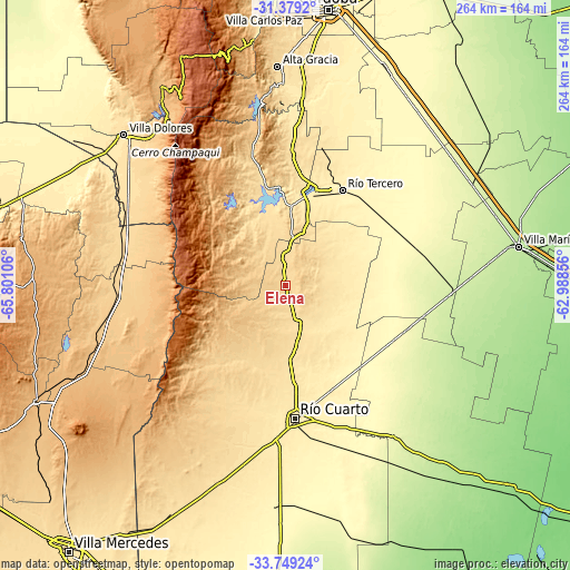
| \ | Map #1 | Topo.Map |
| Scale [m] | 590..685 m | × |
| Scale [ft] | 1936..2247 ft | × |
| Average | 636.4 m = 2088 ft | × |
| Width | 8.24 km = 5.1 mi | 263.5 km = 163.7 mi |
| Height | 8.24 km = 5.1 mi | 263.5 km = 163.7 mi |
| ↑Max Latitude | -32.535009° | -31.3792° |
| Latitude at center | -32.57205° | -32.57205° |
| ↓Min Latitude | -32.609076° | -33.74924° |
| ← Min Longitude | -64.438755° | -65.80106° |
| Longitude center | -64.39481° | -64.39481° |
| →Max Longitude | -64.350865° | -62.98856° |
Nearby cities:
Cities around Elena sort by population:
• Río Tercero elevation 387 m
51.6 km,  30°
30°
• Embalse 561 m
43.6 km,  357°
357°
• Almafuerte 430 m
44.1 km,  17°
17°
• General Cabrera 298 m
55.7 km,  118°
118°
• Santa Rosa de Calamuchita 598 m
57.5 km,  346°
346°
• Berrotarán 631 m
13.5 km,  2°
2°
• Tancacha 354 m
53.4 km,  46°
46°
• Villa del Dique 546 m
44.3 km, 352°
• Los Cóndores 542 m
30.1 km, 21°
• Villa Rumipal 546 m
43.5 km, 349°
• Carnerillo 322 m
51.6 km,  137°
137°
• Coronel Baigorria 532 m
30.8 km,  174°
174°
Multilingual:
 En español:
Elena elevación 635 m.
 En France:
Elena élévation 635 m.


Sources and notes:
- [note 1] Map square and city borders are not equal. Map elevation data is calculated only from area inside that square.
- [src 1] Elevation data from geonames database provided with same terms of usage.
- [src 2] The elevation map of Elena is generated using elevation data from NASA's 3 arcsec (90m) resolution SRTM data.
- [src 3] Base (background) map © OpenStreetMap contributors tiles are generated by Geofabrik and OpenTopoMap.
Copyright & License:
This Elena Elevation Map is licensed under CC BY-SA. You may reuse any part from this page, if you give a proper credit by linking to this URL:
 More info on terms of use page.