Justo Daract elevation
Justo Daract (San Luis, Departamento de General Pedernera), Argentina elevation is 421 meters and Justo Daract elevation in feet is 1381 ft above sea level [src 1]. Justo Daract is a populated place (feature code) with elevation that is 71 meters (233 ft) bigger than average city elevation in Argentina.
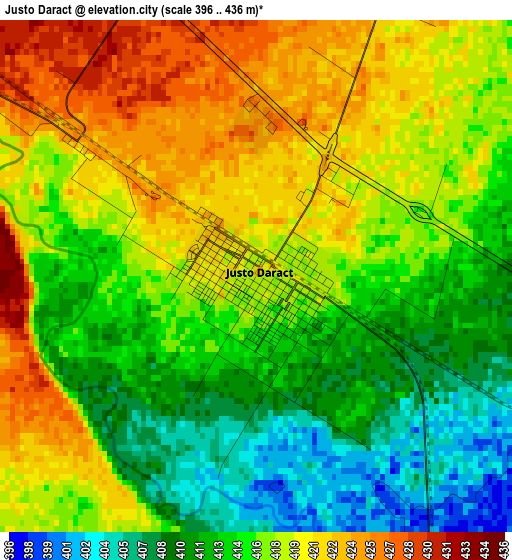
Below is the Elevation map of Justo Daract, which displays elevation range with different colors. Scale of the first map is from 396 to 436 m (1299 to 1430 ft) with average elevation of 416.1 meters (=1365 ft) [note 1]
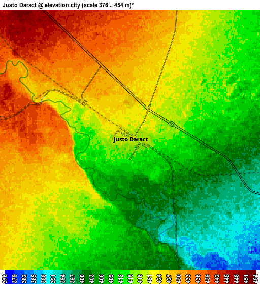
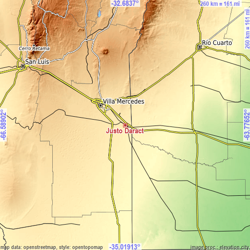
These maps also provides idea of topography and contour of this city, they are displayed at different zoom levels. More info about maps, scale and edge coordinates you can find below images.
| \ | Map #1 | Map #2 | Topo.Map |
| Scale [m] | 396..436 m | 376..454 m | × |
| Scale [ft] | 1299..1430 ft | 1234..1490 ft | × |
| Average | 416.1 m = 1365 ft | 417.1 m = 1368 ft | × |
| Width | 8.12 km = 5 mi | 16.23 km = 10.1 mi | 259.7 km = 161.4 mi |
| Height | 8.12 km = 5 mi | 16.23 km = 10.1 mi | 259.7 km = 161.4 mi |
| ↑Max Latitude | -33.8229° | -33.786384° | -32.6837° |
| Latitude at center | -33.8594° | -33.8594° | -33.8594° |
| ↓Min Latitude | -33.895885° | -33.932354° | -35.01913° |
| ← Min Longitude | -65.226715° | -65.270661° | -66.58902° |
| Longitude center | -65.18277° | -65.18277° | -65.18277° |
| →Max Longitude | -65.138825° | -65.094879° | -63.77652° |
Nearby cities:
Cities around Justo Daract sort by population:
• Villa Mercedes elevation 516 m
32.6 km,  308°
308°
• Vicuña Mackenna 243 m
73.3 km,  95°
95°
• Coronel Moldes 365 m
60.2 km,  64°
64°
• Sampacho 513 m
67.9 km,  38°
38°
• La Toma 897 m
98.6 km,  335°
335°
• Adelia María 266 m
110.4 km,  76°
76°
• Naschel 867 m
106.3 km,  350°
350°
• Del Campillo 228 m
85.5 km,  132°
132°
• San Basilio 303 m
89.8 km, 63°
• Buena Esperanza 323 m
100 km,  183°
183°
• Villa Valeria 297 m
58.7 km,  155°
155°
• Achiras 832 m
78.1 km,  13°
13°
Multilingual:
 En español:
Justo Daract elevación 421 m.
 En France:
Justo Daract élévation 421 m.
 Auf Deutsch:
Justo Daract höhe über dem Meeresspiegel ist 421 m.

Sources and notes:
- [note 1] Map square and city borders are not equal. Map elevation data is calculated only from area inside that square.
- [src 1] Elevation data from geonames database provided with same terms of usage.
- [src 2] The elevation map of Justo Daract is generated using elevation data from NASA's 3 arcsec (90m) resolution SRTM data.
- [src 3] Base (background) map © OpenStreetMap contributors tiles are generated by Geofabrik and OpenTopoMap.
Copyright & License:
This Justo Daract Elevation Map is licensed under CC BY-SA. You may reuse any part from this page, if you give a proper credit by linking to this URL:
 More info on terms of use page.