General Levalle elevation
General Levalle (Cordoba, Departamento de Presidente Roque Sáenz Peña), Argentina elevation is 180 meters and General Levalle elevation in feet is 591 ft above sea level [src 1]. General Levalle is a populated place (feature code) with elevation that is 170 meters (558 ft) smaller than average city elevation in Argentina.
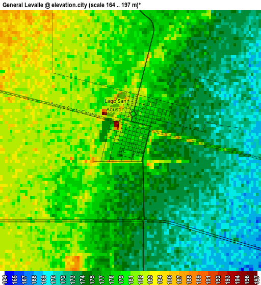
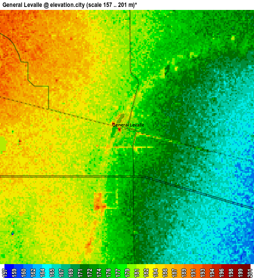
Below is the Elevation map of General Levalle, which displays elevation range with different colors. Scale of the first map is from 164 to 197 m (538 to 646 ft) with average elevation of 177.5 meters (=582 ft) [note 1]
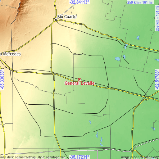
These maps also provides idea of topography and contour of this city, they are displayed at different zoom levels. More info about maps, scale and edge coordinates you can find below images.
| \ | Map #1 | Map #2 | Topo.Map |
| Scale [m] | 164..197 m | 157..201 m | × |
| Scale [ft] | 538..646 ft | 515..659 ft | × |
| Average | 177.5 m = 582 ft | 176.9 m = 580 ft | × |
| Width | 8.1 km = 5 mi | 16.2 km = 10.1 mi | 259.2 km = 161.1 mi |
| Height | 8.1 km = 5 mi | 16.2 km = 10.1 mi | 259.2 km = 161.1 mi |
| ↑Max Latitude | -33.978286° | -33.941837° | -32.84113° |
| Latitude at center | -34.01472° | -34.01472° | -34.01472° |
| ↓Min Latitude | -34.051138° | -34.087541° | -35.17231° |
| ← Min Longitude | -63.968075° | -64.012021° | -65.33038° |
| Longitude center | -63.92413° | -63.92413° | -63.92413° |
| →Max Longitude | -63.880185° | -63.836239° | -62.51788° |
Nearby cities:
Cities around General Levalle sort by population:
• Laboulaye elevation 143 m
50.6 km,  104°
104°
• Vicuña Mackenna 243 m
44.4 km,  283°
283°
• Coronel Moldes 365 m
75.9 km,  305°
305°
• Adelia María 266 m
43.5 km,  348°
348°
• Alejandro Roca 216 m
75.9 km,  14°
14°
• Santa Magdalena 158 m
56 km,  181°
181°
• Del Campillo 228 m
66.1 km,  232°
232°
• San Basilio 303 m
67.9 km,  327°
327°
• Serrano 147 m
61.8 km,  144°
144°
• Las Acequias 295 m
81.7 km,  356°
356°
• Mattaldi 181 m
56.7 km,  203°
203°
• Huanchillas 161 m
46.9 km,  34°
34°
Multilingual:
 En español:
General Levalle elevación 180 m.
 En France:
General Levalle élévation 180 m.
 Auf Deutsch:
General Levalle höhe über dem Meeresspiegel ist 180 m.

Sources and notes:
- [note 1] Map square and city borders are not equal. Map elevation data is calculated only from area inside that square.
- [src 1] Elevation data from geonames database provided with same terms of usage.
- [src 2] The elevation map of General Levalle is generated using elevation data from NASA's 3 arcsec (90m) resolution SRTM data.
- [src 3] Base (background) map © OpenStreetMap contributors tiles are generated by Geofabrik and OpenTopoMap.
Copyright & License:
This General Levalle Elevation Map is licensed under CC BY-SA. You may reuse any part from this page, if you give a proper credit by linking to this URL:
 More info on terms of use page.