Laboulaye elevation
Laboulaye (Cordoba, Departamento de Presidente Roque Sáenz Peña), Argentina elevation is 143 meters and Laboulaye elevation in feet is 469 ft above sea level [src 1]. Laboulaye is a seat of a second-order administrative division (feature code) with elevation that is 207 meters (679 ft) smaller than average city elevation in Argentina.
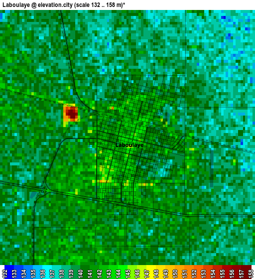
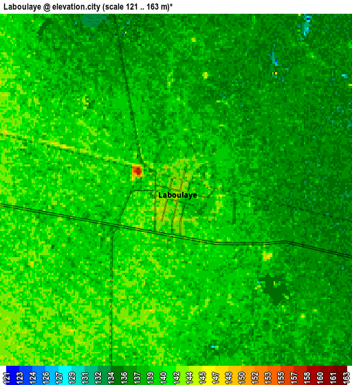
Below is the Elevation map of Laboulaye, which displays elevation range with different colors. Scale of the first map is from 132 to 158 m (433 to 518 ft) with average elevation of 139.5 meters (=458 ft) [note 1]
These maps also provides idea of topography and contour of this city, they are displayed at different zoom levels. More info about maps, scale and edge coordinates you can find below images.
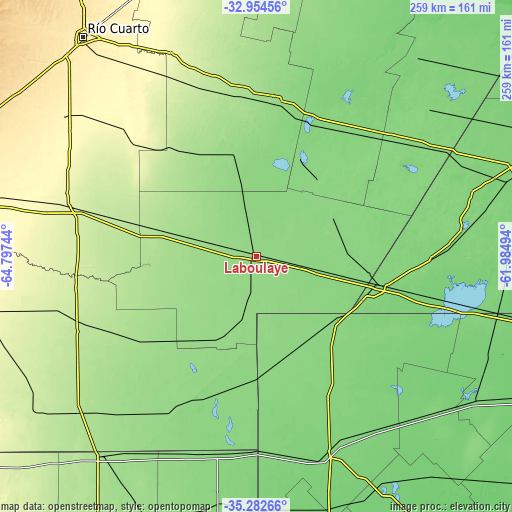
| \ | Map #1 | Map #2 | Topo.Map |
| Scale [m] | 132..158 m | 121..163 m | × |
| Scale [ft] | 433..518 ft | 397..535 ft | × |
| Average | 139.5 m = 458 ft | 138.6 m = 455 ft | × |
| Width | 8.09 km = 5 mi | 16.18 km = 10.1 mi | 258.9 km = 160.9 mi |
| Height | 8.09 km = 5 mi | 16.18 km = 10.1 mi | 258.9 km = 160.9 mi |
| ↑Max Latitude | -34.090234° | -34.053833° | -32.95456° |
| Latitude at center | -34.12662° | -34.12662° | -34.12662° |
| ↓Min Latitude | -34.16299° | -34.199345° | -35.28266° |
| ← Min Longitude | -63.435135° | -63.479081° | -64.79744° |
| Longitude center | -63.39119° | -63.39119° | -63.39119° |
| →Max Longitude | -63.347245° | -63.303299° | -61.98494° |
Nearby cities:
Cities around Laboulaye sort by population:
• Rufino elevation 118 m
64.4 km,  104°
104°
• La Carlota 147 m
79.1 km,  6°
6°
• Canals 127 m
77.7 km,  36°
36°
• Adelia María 266 m
80.1 km,  313°
313°
• General Levalle 180 m
50.6 km,  284°
284°
• Santa Magdalena 158 m
66.9 km,  229°
229°
• Serrano 147 m
40.5 km,  199°
199°
• Buchardo 133 m
67.1 km,  189°
189°
• Mattaldi 181 m
81.9 km,  241°
241°
• Viamonte 131 m
50.2 km,  32°
32°
• La Cesira 133 m
43.2 km,  63°
63°
• Huanchillas 161 m
56 km,  336°
336°
Multilingual:
 En español:
Laboulaye elevación 143 m.
 En France:
Laboulaye élévation 143 m.
 Auf Deutsch:
Laboulaye höhe über dem Meeresspiegel ist 143 m.

Sources and notes:
- [note 1] Map square and city borders are not equal. Map elevation data is calculated only from area inside that square.
- [src 1] Elevation data from geonames database provided with same terms of usage.
- [src 2] The elevation map of Laboulaye is generated using elevation data from NASA's 3 arcsec (90m) resolution SRTM data.
- [src 3] Base (background) map © OpenStreetMap contributors tiles are generated by Geofabrik and OpenTopoMap.
Copyright & License:
This Laboulaye Elevation Map is licensed under CC BY-SA. You may reuse any part from this page, if you give a proper credit by linking to this URL:
 More info on terms of use page.