La Carlota elevation
La Carlota (Cordoba, Departamento de Juárez Celman), Argentina elevation is 147 meters and La Carlota elevation in feet is 482 ft above sea level [src 1]. La Carlota is a seat of a second-order administrative division (feature code) with elevation that is 203 meters (666 ft) smaller than average city elevation in Argentina.
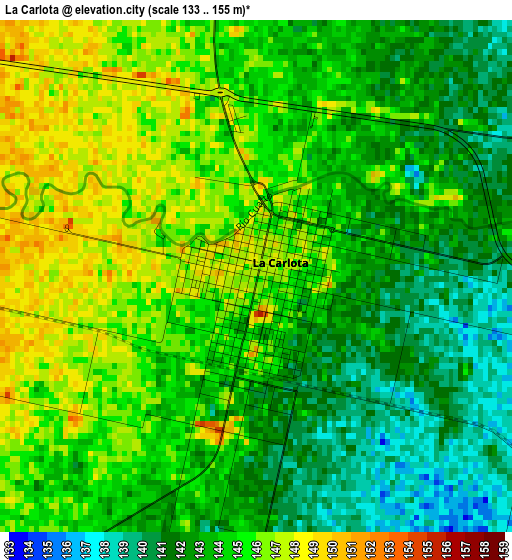
Below is the Elevation map of La Carlota, which displays elevation range with different colors. Scale of the first map is from 133 to 155 m (436 to 509 ft) with average elevation of 143.7 meters (=471 ft) [note 1]
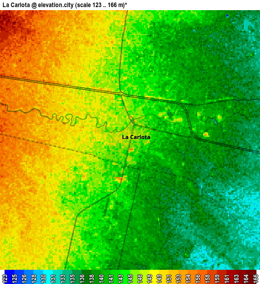
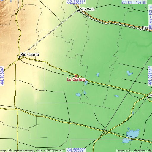
These maps also provides idea of topography and contour of this city, they are displayed at different zoom levels. More info about maps, scale and edge coordinates you can find below images.
| \ | Map #1 | Map #2 | Topo.Map |
| Scale [m] | 133..155 m | 123..166 m | × |
| Scale [ft] | 436..509 ft | 404..545 ft | × |
| Average | 143.7 m = 471 ft | 143.7 m = 471 ft | × |
| Width | 8.16 km = 5.1 mi | 16.31 km = 10.1 mi | 261 km = 162.2 mi |
| Height | 8.16 km = 5.1 mi | 16.31 km = 10.1 mi | 261 km = 162.2 mi |
| ↑Max Latitude | -33.383243° | -33.346541° | -32.23831° |
| Latitude at center | -33.41993° | -33.41993° | -33.41993° |
| ↓Min Latitude | -33.456601° | -33.493257° | -34.58569° |
| ← Min Longitude | -63.341635° | -63.385581° | -64.70394° |
| Longitude center | -63.29769° | -63.29769° | -63.29769° |
| →Max Longitude | -63.253745° | -63.209799° | -61.89144° |
Nearby cities:
Cities around La Carlota sort by population:
• Canals elevation 127 m
41.2 km,  113°
113°
• Laborde 127 m
50.6 km,  54°
54°
• Ucacha 197 m
47.3 km,  335°
335°
• Alejandro Roca 216 m
39.8 km,  280°
280°
• Etruria 163 m
53.6 km,  5°
5°
• Pascanas 140 m
40.5 km,  36°
36°
• Santa Eufemia 155 m
27.1 km,  2°
2°
• Viamonte 131 m
40.8 km,  152°
152°
• Wenceslao Escalante 119 m
56.1 km,  60°
60°
• Villa Reducción 265 m
57.8 km,  294°
294°
• Huanchillas 161 m
41.7 km,  228°
228°
• Chazón 164 m
38 km, 2°
Multilingual:
 En español:
La Carlota elevación 147 m.
 En France:
La Carlota élévation 147 m.
 Auf Deutsch:
La Carlota höhe über dem Meeresspiegel ist 147 m.

Sources and notes:
- [note 1] Map square and city borders are not equal. Map elevation data is calculated only from area inside that square.
- [src 1] Elevation data from geonames database provided with same terms of usage.
- [src 2] The elevation map of La Carlota is generated using elevation data from NASA's 3 arcsec (90m) resolution SRTM data.
- [src 3] Base (background) map © OpenStreetMap contributors tiles are generated by Geofabrik and OpenTopoMap.
Copyright & License:
This La Carlota Elevation Map is licensed under CC BY-SA. You may reuse any part from this page, if you give a proper credit by linking to this URL:
 More info on terms of use page.