Laborde elevation
Laborde (Cordoba, Departamento de Unión), Argentina elevation is 127 meters and Laborde elevation in feet is 417 ft above sea level [src 1]. Laborde is a populated place (feature code) with elevation that is 223 meters (732 ft) smaller than average city elevation in Argentina.
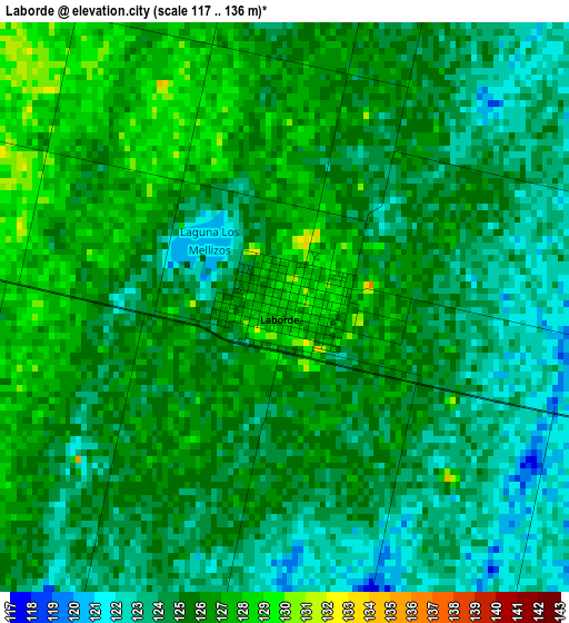
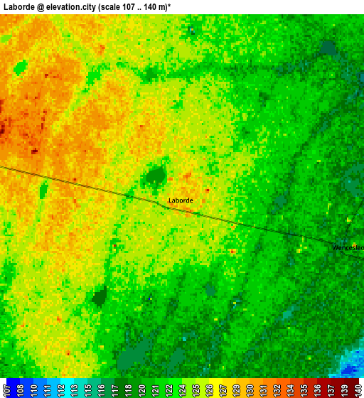
Below is the Elevation map of Laborde, which displays elevation range with different colors. Scale of the first map is from 117 to 136 m (384 to 446 ft) with average elevation of 124.8 meters (=409 ft) [note 1]
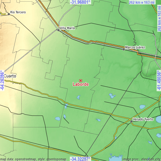
These maps also provides idea of topography and contour of this city, they are displayed at different zoom levels. More info about maps, scale and edge coordinates you can find below images.
| \ | Map #1 | Map #2 | Topo.Map |
| Scale [m] | 117..136 m | 107..140 m | × |
| Scale [ft] | 384..446 ft | 351..459 ft | × |
| Average | 124.8 m = 409 ft | 123.4 m = 405 ft | × |
| Width | 8.18 km = 5.1 mi | 16.36 km = 10.2 mi | 261.8 km = 162.7 mi |
| Height | 8.18 km = 5.1 mi | 16.36 km = 10.2 mi | 261.8 km = 162.7 mi |
| ↑Max Latitude | -33.116391° | -33.079576° | -31.96801° |
| Latitude at center | -33.15319° | -33.15319° | -33.15319° |
| ↓Min Latitude | -33.189974° | -33.226742° | -34.32257° |
| ← Min Longitude | -62.900555° | -62.944501° | -64.26286° |
| Longitude center | -62.85661° | -62.85661° | -62.85661° |
| →Max Longitude | -62.812665° | -62.768719° | -61.45036° |
Nearby cities:
Cities around Laborde sort by population:
• Canals elevation 127 m
45.9 km,  183°
183°
• Justiniano Posse 120 m
34.2 km,  29°
29°
• Monte Maíz 119 m
24.5 km,  103°
103°
• Monte Buey 113 m
45.6 km,  54°
54°
• Isla Verde 121 m
43.3 km, 103°
• Etruria 163 m
43.4 km,  303°
303°
• Pascanas 140 m
17.4 km,  280°
280°
• Ordóñez 138 m
34.8 km,  358°
358°
• Santa Eufemia 155 m
39.8 km,  266°
266°
• Idiazábal 150 m
41.1 km,  336°
336°
• Wenceslao Escalante 119 m
8.3 km,  105°
105°
• Chazón 164 m
40 km, 281°
Multilingual:
 En español:
Laborde elevación 127 m.
 En France:
Laborde élévation 127 m.


Sources and notes:
- [note 1] Map square and city borders are not equal. Map elevation data is calculated only from area inside that square.
- [src 1] Elevation data from geonames database provided with same terms of usage.
- [src 2] The elevation map of Laborde is generated using elevation data from NASA's 3 arcsec (90m) resolution SRTM data.
- [src 3] Base (background) map © OpenStreetMap contributors tiles are generated by Geofabrik and OpenTopoMap.
Copyright & License:
This Laborde Elevation Map is licensed under CC BY-SA. You may reuse any part from this page, if you give a proper credit by linking to this URL:
 More info on terms of use page.