Ucacha elevation
Ucacha (Cordoba, Departamento de Juárez Celman), Argentina elevation is 197 meters and Ucacha elevation in feet is 646 ft above sea level [src 1]. Ucacha is a populated place (feature code) with elevation that is 153 meters (502 ft) smaller than average city elevation in Argentina.
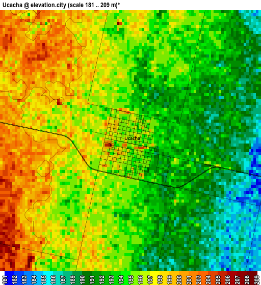
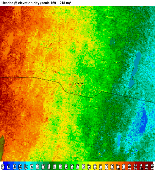
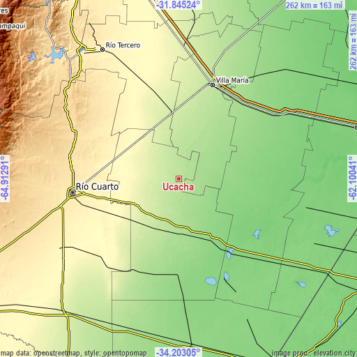
Below is the Elevation map of Ucacha, which displays elevation range with different colors. Scale of the first map is from 181 to 209 m (594 to 686 ft) with average elevation of 194.9 meters (=639 ft) [note 1]
These maps also provides idea of topography and contour of this city, they are displayed at different zoom levels. More info about maps, scale and edge coordinates you can find below images.
| \ | Map #1 | Map #2 | Topo.Map |
| Scale [m] | 181..209 m | 169..218 m | × |
| Scale [ft] | 594..686 ft | 554..715 ft | × |
| Average | 194.9 m = 639 ft | 194.5 m = 638 ft | × |
| Width | 8.19 km = 5.1 mi | 16.39 km = 10.2 mi | 262.2 km = 162.9 mi |
| Height | 8.19 km = 5.1 mi | 16.39 km = 10.2 mi | 262.2 km = 162.9 mi |
| ↑Max Latitude | -32.99518° | -32.958315° | -31.84524° |
| Latitude at center | -33.03203° | -33.03203° | -33.03203° |
| ↓Min Latitude | -33.068865° | -33.105684° | -34.20305° |
| ← Min Longitude | -63.550605° | -63.594551° | -64.91291° |
| Longitude center | -63.50666° | -63.50666° | -63.50666° |
| →Max Longitude | -63.462715° | -63.418769° | -62.10041° |
Nearby cities:
Cities around Ucacha sort by population:
• La Carlota elevation 147 m
47.3 km,  155°
155°
• General Cabrera 298 m
41.9 km,  305°
305°
• Alejandro Roca 216 m
40.8 km,  208°
208°
• Las Perdices 253 m
41.6 km,  333°
333°
• Etruria 163 m
26.3 km,  67°
67°
• Pascanas 140 m
44.6 km,  103°
103°
• Santa Eufemia 155 m
26.3 km,  127°
127°
• Ticino 204 m
38.2 km,  9°
9°
• Villa Reducción 265 m
38.1 km,  240°
240°
• Dalmacio Vélez Sársfield 235 m
47.3 km,  351°
351°
• Pasco 187 m
35.2 km,  25°
25°
• Chazón 164 m
22.1 km, 103°
Multilingual:
 En español:
Ucacha elevación 197 m.
 En France:
Ucacha élévation 197 m.


Sources and notes:
- [note 1] Map square and city borders are not equal. Map elevation data is calculated only from area inside that square.
- [src 1] Elevation data from geonames database provided with same terms of usage.
- [src 2] The elevation map of Ucacha is generated using elevation data from NASA's 3 arcsec (90m) resolution SRTM data.
- [src 3] Base (background) map © OpenStreetMap contributors tiles are generated by Geofabrik and OpenTopoMap.
Copyright & License:
This Ucacha Elevation Map is licensed under CC BY-SA. You may reuse any part from this page, if you give a proper credit by linking to this URL:
 More info on terms of use page.