Bāmyān elevation
Bāmyān (Bamyan), Afghanistan elevation is 2550 meters and Bāmyān elevation in feet is 8366 ft above sea level [src 1]. Bāmyān is a seat of a first-order administrative division (feature code) with elevation that is 1131 meters (3711 ft) bigger than average city elevation in Afghanistan.
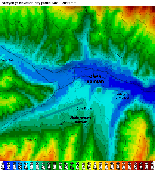
Below is the Elevation map of Bāmyān, which displays elevation range with different colors. Scale of the first map is from 2461 to 3019 m (8074 to 9905 ft) with average elevation of 2642.1 meters (=8668 ft) [note 1]
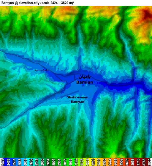
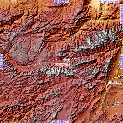
These maps also provides idea of topography and contour of this city, they are displayed at different zoom levels. More info about maps, scale and edge coordinates you can find below images.
| \ | Map #1 | Map #2 | Topo.Map |
| Scale [m] | 2461..3019 m | 2424..3820 m | × |
| Scale [ft] | 8074..9905 ft | 7953..12533 ft | × |
| Average | 2642.1 m = 8668 ft | 2809.5 m = 9218 ft | × |
| Width | 8.02 km = 5 mi | 16.05 km = 10 mi | 256.7 km = 159.5 mi |
| Height | 8.02 km = 5 mi | 16.05 km = 10 mi | 256.7 km = 159.5 mi |
| ↑Max Latitude | 34.857628° | 34.893681° | 35.96787° |
| Latitude at center | 34.82156° | 34.82156° | 34.82156° |
| ↓Min Latitude | 34.785476° | 34.749376° | 33.65907° |
| ← Min Longitude | 67.783395° | 67.739449° | 66.42109° |
| Longitude center | 67.82734° | 67.82734° | 67.82734° |
| →Max Longitude | 67.871285° | 67.915231° | 69.23359° |
Nearby cities:
Cities around Bāmyān sort by population:
• Panjāb elevation 2728 m
88 km,  236°
236°
• Siyāhgird 1878 m
96 km,  77°
77°
• Jalrēz 2347 m
85.1 km,  117°
117°
• Dūāb 2238 m
82.4 km,  359°
359°
• Nayak 2554 m
80.4 km,  263°
263°
• Mīrān 2457 m
80.3 km,  146°
146°
• Bāzār-e Tālah 1206 m
72.9 km,  29°
29°
• Dahan-e Jarf 2306 m
59.2 km, 78°
• Rū-ye Sang 1751 m
58.1 km,  342°
342°
• Wulêswālī Bihsūd 2960 m
53.6 km,  172°
172°
• Khudāydād Khēl 2030 m
41.7 km, 342°
• Bulōlah 2430 m
24.6 km, 75°
Multilingual:
 En español:
Bāmyān elevación 2550 m.
 En France:
Bāmyān élévation 2550 m.


Sources and notes:
- [note 1] Map square and city borders are not equal. Map elevation data is calculated only from area inside that square.
- [src 1] Elevation data from geonames database provided with same terms of usage.
- [src 2] The elevation map of Bāmyān is generated using elevation data from NASA's 3 arcsec (90m) resolution SRTM data.
- [src 3] Base (background) map © OpenStreetMap contributors tiles are generated by Geofabrik and OpenTopoMap.
Copyright & License:
This Bāmyān Elevation Map is licensed under CC BY-SA. You may reuse any part from this page, if you give a proper credit by linking to this URL:
 More info on terms of use page.