Rū-ye Sang elevation
Rū-ye Sang (Bamyan, Kahmard), Afghanistan elevation is 1751 meters and Rū-ye Sang elevation in feet is 5745 ft above sea level [src 1]. Rū-ye Sang is a seat of a second-order administrative division (feature code) with elevation that is 332 meters (1089 ft) bigger than average city elevation in Afghanistan.
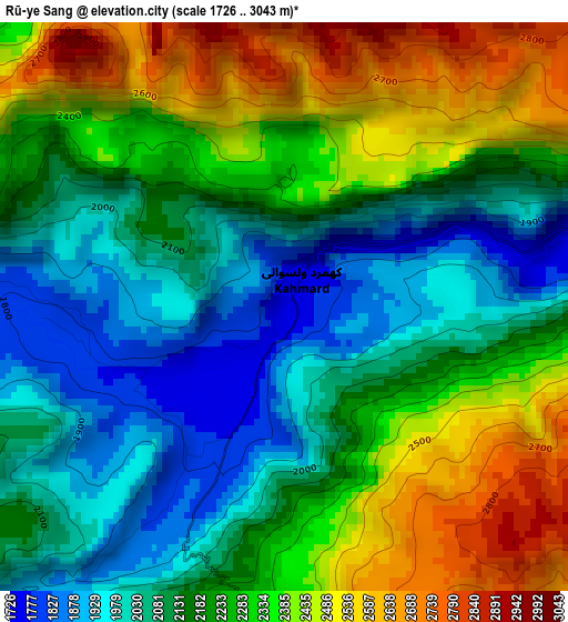
Below is the Elevation map of Rū-ye Sang, which displays elevation range with different colors. Scale of the first map is from 1726 to 3043 m (5663 to 9984 ft) with average elevation of 2221.6 meters (=7289 ft) [note 1]
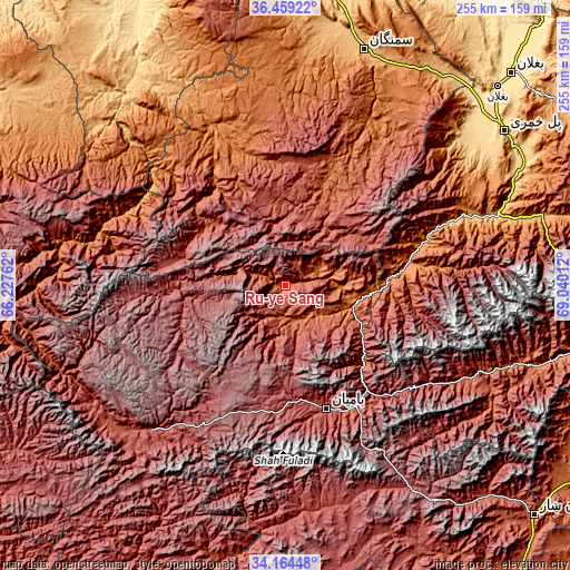
These maps also provides idea of topography and contour of this city, they are displayed at different zoom levels. More info about maps, scale and edge coordinates you can find below images.
| \ | Map #1 | Topo.Map |
| Scale [m] | 1726..3043 m | × |
| Scale [ft] | 5663..9984 ft | × |
| Average | 2221.6 m = 7289 ft | × |
| Width | 7.97 km = 5 mi | 255.2 km = 158.6 mi |
| Height | 7.97 km = 5 mi | 255.2 km = 158.6 mi |
| ↑Max Latitude | 35.355839° | 36.45922° |
| Latitude at center | 35.31999° | 35.31999° |
| ↓Min Latitude | 35.284125° | 34.16448° |
| ← Min Longitude | 67.589925° | 66.22762° |
| Longitude center | 67.63387° | 67.63387° |
| →Max Longitude | 67.677815° | 69.04012° |
Nearby cities:
Cities around Rū-ye Sang sort by population:
• Bāmyān elevation 2550 m
58.1 km,  162°
162°
• Larkird 1508 m
89.9 km,  282°
282°
• Ḩukūmatī Dahanah-ye Ghōrī 801 m
101.1 km,  49°
49°
• Dōshī 836 m
100.5 km,  71°
71°
• Nayak 2554 m
89.9 km,  223°
223°
• Dahan-e Jarf 2306 m
87 km,  119°
119°
• Langar 1440 m
83.9 km,  26°
26°
• Dehī 1271 m
77.8 km,  335°
335°
• Bulōlah 2430 m
64.3 km,  140°
140°
• Bāzār-e Tālah 1206 m
54 km,  81°
81°
• Dūāb 2238 m
31.9 km, 32°
• Khudāydād Khēl 2030 m
16.5 km, 162°
Multilingual:
 En español:
Rū-ye Sang elevación 1751 m.
 En France:
Rū-ye Sang élévation 1751 m.
 Auf Deutsch:
Rū-ye Sang höhe über dem Meeresspiegel ist 1751 m.

Sources and notes:
- [note 1] Map square and city borders are not equal. Map elevation data is calculated only from area inside that square.
- [src 1] Elevation data from geonames database provided with same terms of usage.
- [src 2] The elevation map of Rū-ye Sang is generated using elevation data from NASA's 3 arcsec (90m) resolution SRTM data.
- [src 3] Base (background) map © OpenStreetMap contributors tiles are generated by Geofabrik and OpenTopoMap.
Copyright & License:
This Rū-ye Sang Elevation Map is licensed under CC BY-SA. You may reuse any part from this page, if you give a proper credit by linking to this URL:
 More info on terms of use page.