Larkird elevation
Larkird (Sar-e Pol, Balkhāb), Afghanistan elevation is 1508 meters and Larkird elevation in feet is 4948 ft above sea level [src 1]. Larkird is a populated place (feature code) with elevation that is 89 meters (292 ft) bigger than average city elevation in Afghanistan.
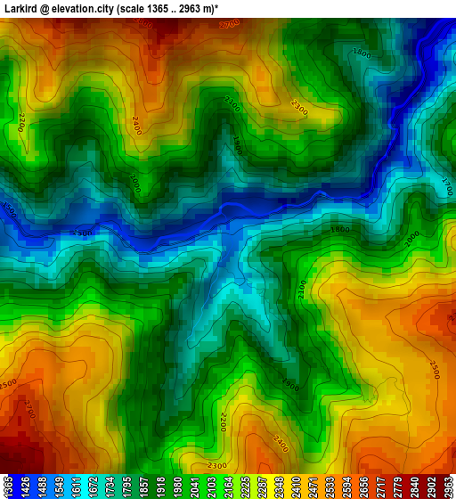
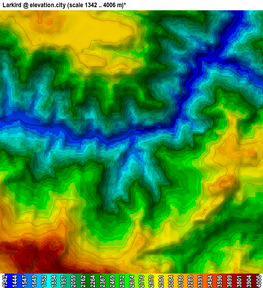
Below is the Elevation map of Larkird, which displays elevation range with different colors. Scale of the first map is from 1365 to 2963 m (4478 to 9721 ft) with average elevation of 2073.7 meters (=6803 ft) [note 1]
These maps also provides idea of topography and contour of this city, they are displayed at different zoom levels. More info about maps, scale and edge coordinates you can find below images.
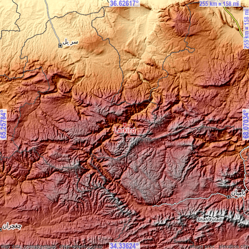
| \ | Map #1 | Map #2 | Topo.Map |
| Scale [m] | 1365..2963 m | 1342..4006 m | × |
| Scale [ft] | 4478..9721 ft | 4403..13143 ft | × |
| Average | 2073.7 m = 6803 ft | 2425.4 m = 7957 ft | × |
| Width | 7.96 km = 4.9 mi | 15.91 km = 9.9 mi | 254.6 km = 158.2 mi |
| Height | 7.96 km = 4.9 mi | 15.91 km = 9.9 mi | 254.6 km = 158.2 mi |
| ↑Max Latitude | 35.525133° | 35.560891° | 36.62617° |
| Latitude at center | 35.48936° | 35.48936° | 35.48936° |
| ↓Min Latitude | 35.453571° | 35.417766° | 34.33624° |
| ← Min Longitude | 66.620145° | 66.576199° | 65.25784° |
| Longitude center | 66.66409° | 66.66409° | 66.66409° |
| →Max Longitude | 66.708035° | 66.751981° | 68.07034° |
Nearby cities:
Cities around Larkird sort by population:
• Sang-e Chārak elevation 1483 m
45 km,  332°
332°
• Chīras 2691 m
62.3 km,  262°
262°
• Tukzār 1210 m
55.5 km,  336°
336°
• Tagāw-Bāy 1666 m
59.3 km,  293°
293°
• Lab-Sar 1011 m
61.7 km,  14°
14°
• Khudāydād Khēl 2030 m
99.1 km,  110°
110°
• Rū-ye Sang 1751 m
89.9 km,  102°
102°
• Nayak 2554 m
88 km,  162°
162°
• Pasnay 1759 m
86.9 km, 290°
• Sōzmah Qal‘ah 870 m
79.3 km, 328°
• Dehī 1271 m
76.2 km,  46°
46°
• Āq Kupruk 719 m
67.9 km, 13°
Multilingual:
 En español:
Larkird elevación 1508 m.
 En France:
Larkird élévation 1508 m.
 Auf Deutsch:
Larkird höhe über dem Meeresspiegel ist 1508 m.

Sources and notes:
- [note 1] Map square and city borders are not equal. Map elevation data is calculated only from area inside that square.
- [src 1] Elevation data from geonames database provided with same terms of usage.
- [src 2] The elevation map of Larkird is generated using elevation data from NASA's 3 arcsec (90m) resolution SRTM data.
- [src 3] Base (background) map © OpenStreetMap contributors tiles are generated by Geofabrik and OpenTopoMap.
Copyright & License:
This Larkird Elevation Map is licensed under CC BY-SA. You may reuse any part from this page, if you give a proper credit by linking to this URL:
 More info on terms of use page.