Chīras elevation
Chīras (Sar-e Pol, Kōhistānāt), Afghanistan elevation is 2691 meters and Chīras elevation in feet is 8829 ft above sea level [src 1]. Chīras is a populated place (feature code) with elevation that is 1272 meters (4173 ft) bigger than average city elevation in Afghanistan.
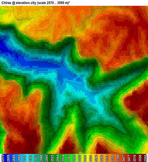
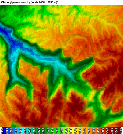
Below is the Elevation map of Chīras, which displays elevation range with different colors. Scale of the first map is from 2570 to 3595 m (8432 to 11795 ft) with average elevation of 3119.7 meters (=10235 ft) [note 1]
These maps also provides idea of topography and contour of this city, they are displayed at different zoom levels. More info about maps, scale and edge coordinates you can find below images.
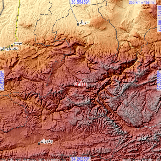
| \ | Map #1 | Map #2 | Topo.Map |
| Scale [m] | 2570..3595 m | 2456..3690 m | × |
| Scale [ft] | 8432..11795 ft | 8058..12106 ft | × |
| Average | 3119.7 m = 10235 ft | 3220.8 m = 10567 ft | × |
| Width | 7.96 km = 4.9 mi | 15.93 km = 9.9 mi | 254.8 km = 158.3 mi |
| Height | 7.96 km = 4.9 mi | 15.93 km = 9.9 mi | 254.8 km = 158.3 mi |
| ↑Max Latitude | 35.452546° | 35.488335° | 36.55459° |
| Latitude at center | 35.41674° | 35.41674° | 35.41674° |
| ↓Min Latitude | 35.380918° | 35.345081° | 34.26259° |
| ← Min Longitude | 65.938395° | 65.894449° | 64.57609° |
| Longitude center | 65.98234° | 65.98234° | 65.98234° |
| →Max Longitude | 66.026285° | 66.070231° | 67.38859° |
Nearby cities:
Cities around Chīras sort by population:
• Sar-e Pul elevation 636 m
88.9 km,  357°
357°
• Sang-e Chārak 1483 m
63.3 km,  40°
40°
• Tukzār 1210 m
71.2 km,  33°
33°
• Larkird 1508 m
62.3 km,  82°
82°
• Darzāb 1179 m
82.8 km,  318°
318°
• Tagāw-Bāy 1666 m
32.2 km,  12°
12°
• Qal‘ah-ye Shahr 2136 m
40.3 km,  291°
291°
• Bal Chirāgh 1163 m
82.6 km,  304°
304°
• Şayād 946 m
81.1 km,  350°
350°
• Sōzmah Qal‘ah 870 m
78.6 km,  15°
15°
• Sar Chakān 1348 m
75 km, 294°
• Pasnay 1759 m
43.6 km,  333°
333°
Multilingual:
 En español:
Chīras elevación 2691 m.
 En France:
Chīras élévation 2691 m.


Sources and notes:
- [note 1] Map square and city borders are not equal. Map elevation data is calculated only from area inside that square.
- [src 1] Elevation data from geonames database provided with same terms of usage.
- [src 2] The elevation map of Chīras is generated using elevation data from NASA's 3 arcsec (90m) resolution SRTM data.
- [src 3] Base (background) map © OpenStreetMap contributors tiles are generated by Geofabrik and OpenTopoMap.
Copyright & License:
This Chīras Elevation Map is licensed under CC BY-SA. You may reuse any part from this page, if you give a proper credit by linking to this URL:
 More info on terms of use page.