Tukzār elevation
Tukzār (Sar-e Pol, Sangchārak), Afghanistan elevation is 1210 meters and Tukzār elevation in feet is 3970 ft above sea level [src 1]. Tukzār is a seat of a second-order administrative division (feature code) with elevation that is 209 meters (686 ft) smaller than average city elevation in Afghanistan.
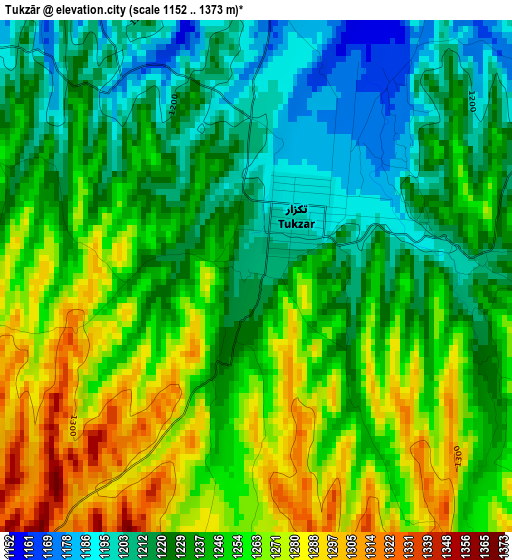
Below is the Elevation map of Tukzār, which displays elevation range with different colors. Scale of the first map is from 1152 to 1373 m (3780 to 4505 ft) with average elevation of 1241.9 meters (=4074 ft) [note 1]
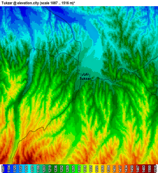
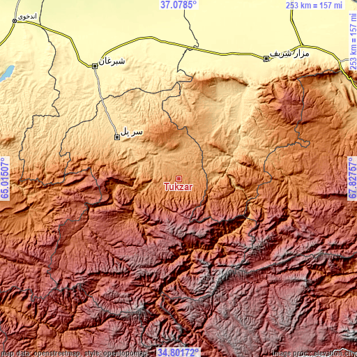
These maps also provides idea of topography and contour of this city, they are displayed at different zoom levels. More info about maps, scale and edge coordinates you can find below images.
| \ | Map #1 | Map #2 | Topo.Map |
| Scale [m] | 1152..1373 m | 1087..1516 m | × |
| Scale [ft] | 3780..4505 ft | 3566..4974 ft | × |
| Average | 1241.9 m = 4074 ft | 1254.1 m = 4115 ft | × |
| Width | 7.91 km = 4.9 mi | 15.82 km = 9.8 mi | 253.2 km = 157.3 mi |
| Height | 7.91 km = 4.9 mi | 15.82 km = 9.8 mi | 253.2 km = 157.3 mi |
| ↑Max Latitude | 35.983878° | 36.01943° | 37.0785° |
| Latitude at center | 35.94831° | 35.94831° | 35.94831° |
| ↓Min Latitude | 35.912726° | 35.877126° | 34.80172° |
| ← Min Longitude | 66.377375° | 66.333429° | 65.01507° |
| Longitude center | 66.42132° | 66.42132° | 66.42132° |
| →Max Longitude | 66.465265° | 66.509211° | 67.82757° |
Nearby cities:
Cities around Tukzār sort by population:
• Sar-e Pul elevation 636 m
53 km,  304°
304°
• Sang-e Chārak 1483 m
11.1 km,  172°
172°
• Chīras 2691 m
71.2 km,  213°
213°
• Larkird 1508 m
55.5 km,  156°
156°
• Tagāw-Bāy 1666 m
42.6 km,  229°
229°
• Lab-Sar 1011 m
38.5 km,  76°
76°
• Chimtāl 355 m
88.1 km,  22°
22°
• Dehī 1271 m
77.3 km,  89°
89°
• Pasnay 1759 m
62.5 km,  251°
251°
• Şayād 946 m
57.1 km,  291°
291°
• Āq Kupruk 719 m
40.6 km,  68°
68°
• Sōzmah Qal‘ah 870 m
25.5 km,  311°
311°
Multilingual:
 En español:
Tukzār elevación 1210 m.
 En France:
Tukzār élévation 1210 m.


Sources and notes:
- [note 1] Map square and city borders are not equal. Map elevation data is calculated only from area inside that square.
- [src 1] Elevation data from geonames database provided with same terms of usage.
- [src 2] The elevation map of Tukzār is generated using elevation data from NASA's 3 arcsec (90m) resolution SRTM data.
- [src 3] Base (background) map © OpenStreetMap contributors tiles are generated by Geofabrik and OpenTopoMap.
Copyright & License:
This Tukzār Elevation Map is licensed under CC BY-SA. You may reuse any part from this page, if you give a proper credit by linking to this URL:
 More info on terms of use page.