Bāzār-e Tālah elevation
Bāzār-e Tālah (Baghlan, Tālah wa Barfak), Afghanistan elevation is 1206 meters and Bāzār-e Tālah elevation in feet is 3957 ft above sea level [src 1]. Bāzār-e Tālah is a seat of a second-order administrative division (feature code) with elevation that is 213 meters (699 ft) smaller than average city elevation in Afghanistan.
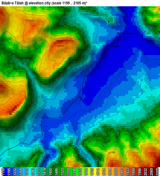
Below is the Elevation map of Bāzār-e Tālah, which displays elevation range with different colors. Scale of the first map is from 1159 to 2105 m (3802 to 6906 ft) with average elevation of 1439 meters (=4721 ft) [note 1]
These maps also provides idea of topography and contour of this city, they are displayed at different zoom levels. More info about maps, scale and edge coordinates you can find below images.
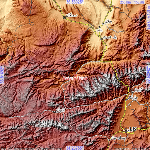
| \ | Map #1 | Topo.Map |
| Scale [m] | 1159..2105 m | × |
| Scale [ft] | 3802..6906 ft | × |
| Average | 1439 m = 4721 ft | × |
| Width | 7.97 km = 5 mi | 254.9 km = 158.4 mi |
| Height | 7.97 km = 5 mi | 254.9 km = 158.4 mi |
| ↑Max Latitude | 35.427867° | 36.53025° |
| Latitude at center | 35.39205° | 35.39205° |
| ↓Min Latitude | 35.356217° | 34.23755° |
| ← Min Longitude | 68.179225° | 66.81692° |
| Longitude center | 68.22317° | 68.22317° |
| →Max Longitude | 68.267115° | 69.62942° |
Nearby cities:
Cities around Bāzār-e Tālah sort by population:
• Bāmyān elevation 2550 m
72.9 km,  209°
209°
• Pul-e Khumrī 638 m
75.8 km,  35°
35°
• Ḩukūmatī Dahanah-ye Ghōrī 801 m
62 km,  22°
22°
• Siyāhgird 1878 m
71.8 km,  126°
126°
• Langar 1440 m
68.8 km,  346°
346°
• Khinjān 1132 m
65.2 km,  70°
70°
• Bulōlah 2430 m
58.6 km,  192°
192°
• Dahan-e Jarf 2306 m
55.9 km,  157°
157°
• Khudāydād Khēl 2030 m
54.1 km,  243°
243°
• Rū-ye Sang 1751 m
54 km,  261°
261°
• Dōshī 836 m
48.3 km,  59°
59°
• Dūāb 2238 m
41 km,  297°
297°
Multilingual:
 En español:
Bāzār-e Tālah elevación 1206 m.
 En France:
Bāzār-e Tālah élévation 1206 m.
 Auf Deutsch:
Bāzār-e Tālah höhe über dem Meeresspiegel ist 1206 m.

Sources and notes:
- [note 1] Map square and city borders are not equal. Map elevation data is calculated only from area inside that square.
- [src 1] Elevation data from geonames database provided with same terms of usage.
- [src 2] The elevation map of Bāzār-e Tālah is generated using elevation data from NASA's 3 arcsec (90m) resolution SRTM data.
- [src 3] Base (background) map © OpenStreetMap contributors tiles are generated by Geofabrik and OpenTopoMap.
Copyright & License:
This Bāzār-e Tālah Elevation Map is licensed under CC BY-SA. You may reuse any part from this page, if you give a proper credit by linking to this URL:
 More info on terms of use page.