Khinjān elevation
Khinjān (Baghlan), Afghanistan elevation is 1132 meters and Khinjān elevation in feet is 3714 ft above sea level [src 1]. Khinjān is a seat of a second-order administrative division (feature code) with elevation that is 287 meters (942 ft) smaller than average city elevation in Afghanistan.
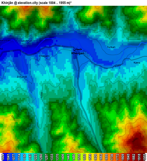
Below is the Elevation map of Khinjān, which displays elevation range with different colors. Scale of the first map is from 1004 to 1955 m (3294 to 6414 ft) with average elevation of 1277 meters (=4190 ft) [note 1]
These maps also provides idea of topography and contour of this city, they are displayed at different zoom levels. More info about maps, scale and edge coordinates you can find below images.
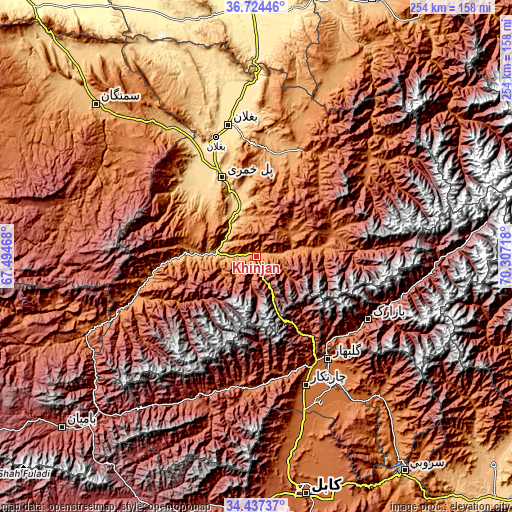
| \ | Map #1 | Topo.Map |
| Scale [m] | 1004..1955 m | × |
| Scale [ft] | 3294..6414 ft | × |
| Average | 1277 m = 4190 ft | × |
| Width | 7.95 km = 4.9 mi | 254.3 km = 158 mi |
| Height | 7.95 km = 4.9 mi | 254.3 km = 158 mi |
| ↑Max Latitude | 35.624809° | 36.72446° |
| Latitude at center | 35.58908° | 35.58908° |
| ↓Min Latitude | 35.553335° | 34.43737° |
| ← Min Longitude | 68.856985° | 67.49468° |
| Longitude center | 68.90093° | 68.90093° |
| →Max Longitude | 68.944875° | 70.30718° |
Nearby cities:
Cities around Khinjān sort by population:
• Baghlān elevation 531 m
62.7 km,  343°
343°
• Pul-e Khumrī 638 m
42.9 km, 337°
• Nahrīn 1138 m
56.9 km,  21°
21°
• Jabal os Saraj 1612 m
60.6 km,  149°
149°
• Ḩukūmatī Dahanah-ye Ghōrī 801 m
51.3 km,  313°
313°
• Qāshqāl 1733 m
61.8 km,  171°
171°
• ’Unābah 1770 m
58.6 km,  132°
132°
• Pul-e Ḩişār 1979 m
51.7 km,  86°
86°
• Bāgh-e Maīdān 1988 m
49.7 km, 145°
• Deh-e Şalāḩ 1632 m
39.1 km,  73°
73°
• Banū 1510 m
32.8 km,  81°
81°
• Dōshī 836 m
19.7 km,  276°
276°
Multilingual:
 En español:
Khinjān elevación 1132 m.
 En France:
Khinjān élévation 1132 m.
 Auf Deutsch:
Khinjān höhe über dem Meeresspiegel ist 1132 m.

Sources and notes:
- [note 1] Map square and city borders are not equal. Map elevation data is calculated only from area inside that square.
- [src 1] Elevation data from geonames database provided with same terms of usage.
- [src 2] The elevation map of Khinjān is generated using elevation data from NASA's 3 arcsec (90m) resolution SRTM data.
- [src 3] Base (background) map © OpenStreetMap contributors tiles are generated by Geofabrik and OpenTopoMap.
Copyright & License:
This Khinjān Elevation Map is licensed under CC BY-SA. You may reuse any part from this page, if you give a proper credit by linking to this URL:
 More info on terms of use page.