Nahrīn elevation
Nahrīn (Baghlan), Afghanistan elevation is 1138 meters and Nahrīn elevation in feet is 3734 ft above sea level [src 1]. Nahrīn is a seat of a second-order administrative division (feature code) with elevation that is 281 meters (922 ft) smaller than average city elevation in Afghanistan.
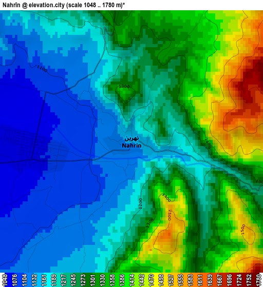
Below is the Elevation map of Nahrīn, which displays elevation range with different colors. Scale of the first map is from 1048 to 1780 m (3438 to 5840 ft) with average elevation of 1248.8 meters (=4097 ft) [note 1]
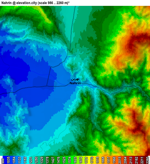
These maps also provides idea of topography and contour of this city, they are displayed at different zoom levels. More info about maps, scale and edge coordinates you can find below images.
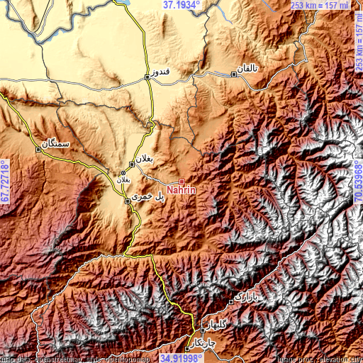
| \ | Map #1 | Map #2 | Topo.Map |
| Scale [m] | 1048..1780 m | 986..2260 m | × |
| Scale [ft] | 3438..5840 ft | 3235..7415 ft | × |
| Average | 1248.8 m = 4097 ft | 1373.6 m = 4507 ft | × |
| Width | 7.9 km = 4.9 mi | 15.8 km = 9.8 mi | 252.8 km = 157.1 mi |
| Height | 7.9 km = 4.9 mi | 15.8 km = 9.8 mi | 252.8 km = 157.1 mi |
| ↑Max Latitude | 36.100415° | 36.135914° | 37.1934° |
| Latitude at center | 36.0649° | 36.0649° | 36.0649° |
| ↓Min Latitude | 36.029369° | 35.993821° | 34.91998° |
| ← Min Longitude | 69.089485° | 69.045539° | 67.72718° |
| Longitude center | 69.13343° | 69.13343° | 69.13343° |
| →Max Longitude | 69.177375° | 69.221321° | 70.53968° |
Nearby cities:
Cities around Nahrīn sort by population:
• Baghlān elevation 531 m
38.9 km,  280°
280°
• Khanabad 503 m
68.7 km,  358°
358°
• Pul-e Khumrī 638 m
39.9 km,  250°
250°
• Ḩukūmatī Dahanah-ye Ghōrī 801 m
60.6 km, 253°
• Afaki 711 m
69.2 km,  16°
16°
• Dōshī 836 m
64.8 km,  218°
218°
• Pul-e Ḩişār 1979 m
58.3 km,  148°
148°
• Khinjān 1132 m
56.9 km,  201°
201°
• Aliabad 426 m
54.9 km,  337°
337°
• Banū 1510 m
49.3 km,  166°
166°
• Deh-e Şalāḩ 1632 m
44.8 km,  158°
158°
• Būrkah 1188 m
17.6 km,  4°
4°
Multilingual:
 En español:
Nahrīn elevación 1138 m.
 En France:
Nahrīn élévation 1138 m.


Sources and notes:
- [note 1] Map square and city borders are not equal. Map elevation data is calculated only from area inside that square.
- [src 1] Elevation data from geonames database provided with same terms of usage.
- [src 2] The elevation map of Nahrīn is generated using elevation data from NASA's 3 arcsec (90m) resolution SRTM data.
- [src 3] Base (background) map © OpenStreetMap contributors tiles are generated by Geofabrik and OpenTopoMap.
Copyright & License:
This Nahrīn Elevation Map is licensed under CC BY-SA. You may reuse any part from this page, if you give a proper credit by linking to this URL:
 More info on terms of use page.