Wulêswālī Bihsūd elevation
Wulêswālī Bihsūd (Vardak, Markazi Bihsud), Afghanistan elevation is 2960 meters and Wulêswālī Bihsūd elevation in feet is 9711 ft above sea level [src 1]. Wulêswālī Bihsūd is a seat of a second-order administrative division (feature code) with elevation that is 1541 meters (5056 ft) bigger than average city elevation in Afghanistan.
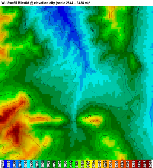
Below is the Elevation map of Wulêswālī Bihsūd, which displays elevation range with different colors. Scale of the first map is from 2844 to 3438 m (9331 to 11280 ft) with average elevation of 3044.4 meters (=9988 ft) [note 1]
These maps also provides idea of topography and contour of this city, they are displayed at different zoom levels. More info about maps, scale and edge coordinates you can find below images.
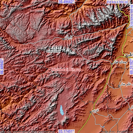
| \ | Map #1 | Topo.Map |
| Scale [m] | 2844..3438 m | × |
| Scale [ft] | 9331..11280 ft | × |
| Average | 3044.4 m = 9988 ft | × |
| Width | 8.07 km = 5 mi | 258.2 km = 160.4 mi |
| Height | 8.07 km = 5 mi | 258.2 km = 160.4 mi |
| ↑Max Latitude | 34.379876° | 35.49662° |
| Latitude at center | 34.3436° | 34.3436° |
| ↓Min Latitude | 34.307308° | 33.17451° |
| ← Min Longitude | 67.861725° | 66.49942° |
| Longitude center | 67.90567° | 67.90567° |
| →Max Longitude | 67.949615° | 69.31192° |
Nearby cities:
Cities around Wulêswālī Bihsūd sort by population:
• Bāmyān elevation 2550 m
53.6 km,  352°
352°
• Panjāb 2728 m
81.1 km,  273°
273°
• Maydanshakhr 2206 m
88.3 km,  86°
86°
• Khudāydād Khēl 2030 m
94.9 km, 347°
• Tōrmay 2296 m
86 km,  147°
147°
• Markaz-e Sayyidābād 2113 m
83.5 km,  117°
117°
• Dahan-e Jarf 2306 m
82.7 km,  38°
38°
• Kalān Deh 2502 m
72.6 km,  140°
140°
• Jalrēz 2347 m
70.1 km,  78°
78°
• Bulōlah 2430 m
61.6 km,  15°
15°
• Ōkak 3068 m
49.8 km,  174°
174°
• Mīrān 2457 m
39.8 km,  110°
110°
Multilingual:
 En español:
Wulêswālī Bihsūd elevación 2960 m.
 En France:
Wulêswālī Bihsūd élévation 2960 m.
 Auf Deutsch:
Wulêswālī Bihsūd höhe über dem Meeresspiegel ist 2960 m.

Sources and notes:
- [note 1] Map square and city borders are not equal. Map elevation data is calculated only from area inside that square.
- [src 1] Elevation data from geonames database provided with same terms of usage.
- [src 2] The elevation map of Wulêswālī Bihsūd is generated using elevation data from NASA's 3 arcsec (90m) resolution SRTM data.
- [src 3] Base (background) map © OpenStreetMap contributors tiles are generated by Geofabrik and OpenTopoMap.
Copyright & License:
This Wulêswālī Bihsūd Elevation Map is licensed under CC BY-SA. You may reuse any part from this page, if you give a proper credit by linking to this URL:
 More info on terms of use page.