Jalrēz elevation
Jalrēz (Vardak, Jalrayz), Afghanistan elevation is 2347 meters and Jalrēz elevation in feet is 7700 ft above sea level [src 1]. Jalrēz is a seat of a second-order administrative division (feature code) with elevation that is 928 meters (3045 ft) bigger than average city elevation in Afghanistan.
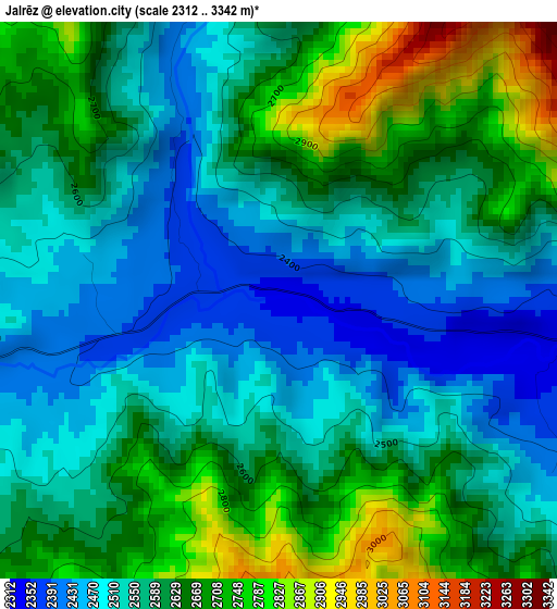
Below is the Elevation map of Jalrēz, which displays elevation range with different colors. Scale of the first map is from 2312 to 3342 m (7585 to 10965 ft) with average elevation of 2591.9 meters (=8504 ft) [note 1]
These maps also provides idea of topography and contour of this city, they are displayed at different zoom levels. More info about maps, scale and edge coordinates you can find below images.
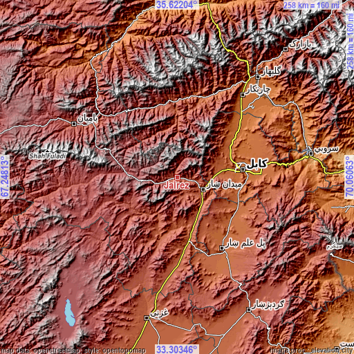
| \ | Map #1 | Topo.Map |
| Scale [m] | 2312..3342 m | × |
| Scale [ft] | 7585..10965 ft | × |
| Average | 2591.9 m = 8504 ft | × |
| Width | 8.06 km = 5 mi | 257.8 km = 160.2 mi |
| Height | 8.06 km = 5 mi | 257.8 km = 160.2 mi |
| ↑Max Latitude | 34.507021° | 35.62204° |
| Latitude at center | 34.4708° | 34.4708° |
| ↓Min Latitude | 34.434563° | 33.30346° |
| ← Min Longitude | 68.610435° | 67.24813° |
| Longitude center | 68.65438° | 68.65438° |
| →Max Longitude | 68.698325° | 70.06063° |
Nearby cities:
Cities around Jalrēz sort by population:
• Kabul elevation 1798 m
47.9 km,  82°
82°
• Paghmān 2328 m
30.1 km,  64°
64°
• Mīr Bachah Kōṯ 1673 m
52.6 km,  53°
53°
• Maydanshakhr 2206 m
21.1 km,  113°
113°
• Markaz-e Sayyidābād 2113 m
52.6 km,  174°
174°
• Zargarān 1935 m
51.1 km, 46°
• Muḩammad Āghah Wuluswālī 1853 m
49.9 km,  124°
124°
• Qal‘ah-ye Na‘īm 1819 m
47.7 km,  99°
99°
• Deh-e Now 1974 m
47.4 km, 49°
• Mīrān 2457 m
42 km,  228°
228°
• Surkh Bilandī 2040 m
41.7 km, 55°
• Chandal Bā’ī 2304 m
30.3 km,  65°
65°
Multilingual:
 En español:
Jalrēz elevación 2347 m.
 En France:
Jalrēz élévation 2347 m.


Sources and notes:
- [note 1] Map square and city borders are not equal. Map elevation data is calculated only from area inside that square.
- [src 1] Elevation data from geonames database provided with same terms of usage.
- [src 2] The elevation map of Jalrēz is generated using elevation data from NASA's 3 arcsec (90m) resolution SRTM data.
- [src 3] Base (background) map © OpenStreetMap contributors tiles are generated by Geofabrik and OpenTopoMap.
Copyright & License:
This Jalrēz Elevation Map is licensed under CC BY-SA. You may reuse any part from this page, if you give a proper credit by linking to this URL:
 More info on terms of use page.