Muḩammad Āghah Wuluswālī elevation
Muḩammad Āghah Wuluswālī (Logar, Muḩammad Āghah), Afghanistan elevation is 1853 meters and Muḩammad Āghah Wuluswālī elevation in feet is 6079 ft above sea level [src 1]. Muḩammad Āghah Wuluswālī is a seat of a second-order administrative division (feature code) with elevation that is 434 meters (1424 ft) bigger than average city elevation in Afghanistan.
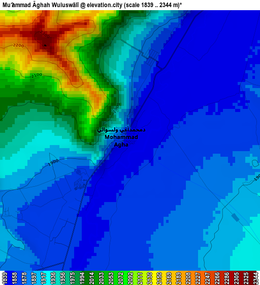
Below is the Elevation map of Muḩammad Āghah Wuluswālī, which displays elevation range with different colors. Scale of the first map is from 1839 to 2344 m (6033 to 7690 ft) with average elevation of 1925 meters (=6316 ft) [note 1]
These maps also provides idea of topography and contour of this city, they are displayed at different zoom levels. More info about maps, scale and edge coordinates you can find below images.
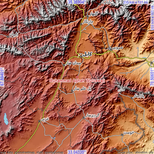
| \ | Map #1 | Topo.Map |
| Scale [m] | 1839..2344 m | × |
| Scale [ft] | 6033..7690 ft | × |
| Average | 1925 m = 6316 ft | × |
| Width | 8.08 km = 5 mi | 258.6 km = 160.7 mi |
| Height | 8.08 km = 5 mi | 258.6 km = 160.7 mi |
| ↑Max Latitude | 34.250552° | 35.36904° |
| Latitude at center | 34.21422° | 34.21422° |
| ↓Min Latitude | 34.177872° | 33.04335° |
| ← Min Longitude | 69.056315° | 67.69401° |
| Longitude center | 69.10026° | 69.10026° |
| →Max Longitude | 69.144205° | 70.50651° |
Nearby cities:
Cities around Muḩammad Āghah Wuluswālī sort by population:
• Kabul elevation 1798 m
35.5 km,  10°
10°
• Paghmān 2328 m
43.7 km,  341°
341°
• Baraki Barak 1940 m
30.8 km,  206°
206°
• Pul-e ‘Alam 1921 m
25.4 km,  196°
196°
• Maydanshakhr 2206 m
29.5 km,  313°
313°
• Pul-e Sangī 1776 m
45.3 km,  18°
18°
• Chandal Bā’ī 2304 m
43.3 km, 342°
• Markaz-e Sayyidābād 2113 m
42.8 km,  236°
236°
• Bagrāmī 1788 m
34.9 km,  27°
27°
• Chakaray 2372 m
34.1 km,  65°
65°
• Khōshī 2252 m
26.2 km,  156°
156°
• Qal‘ah-ye Na‘īm 1819 m
21.5 km, 16°
Multilingual:
 En español:
Muḩammad Āghah Wuluswālī elevación 1853 m.
 En France:
Muḩammad Āghah Wuluswālī élévation 1853 m.
 Auf Deutsch:
Muḩammad Āghah Wuluswālī höhe über dem Meeresspiegel ist 1853 m.
 На русском:
Muḩammad Āghah Wuluswālī высота над уровнем моря 1853 м
Sources and notes:
- [note 1] Map square and city borders are not equal. Map elevation data is calculated only from area inside that square.
- [src 1] Elevation data from geonames database provided with same terms of usage.
- [src 2] The elevation map of Muḩammad Āghah Wuluswālī is generated using elevation data from NASA's 3 arcsec (90m) resolution SRTM data.
- [src 3] Base (background) map © OpenStreetMap contributors tiles are generated by Geofabrik and OpenTopoMap.
Copyright & License:
This Muḩammad Āghah Wuluswālī Elevation Map is licensed under CC BY-SA. You may reuse any part from this page, if you give a proper credit by linking to this URL:
 More info on terms of use page.