Paghmān elevation
Paghmān (Kabul), Afghanistan elevation is 2328 meters and Paghmān elevation in feet is 7638 ft above sea level [src 1]. Paghmān is a populated place (feature code) with elevation that is 909 meters (2982 ft) bigger than average city elevation in Afghanistan.
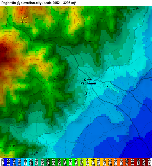
Below is the Elevation map of Paghmān, which displays elevation range with different colors. Scale of the first map is from 2052 to 3296 m (6732 to 10814 ft) with average elevation of 2420.7 meters (=7942 ft) [note 1]
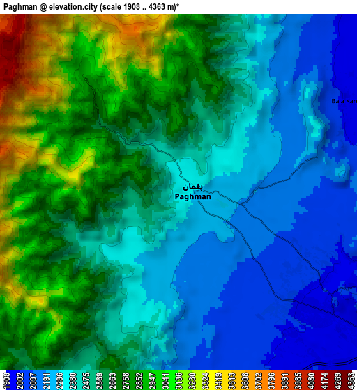
These maps also provides idea of topography and contour of this city, they are displayed at different zoom levels. More info about maps, scale and edge coordinates you can find below images.
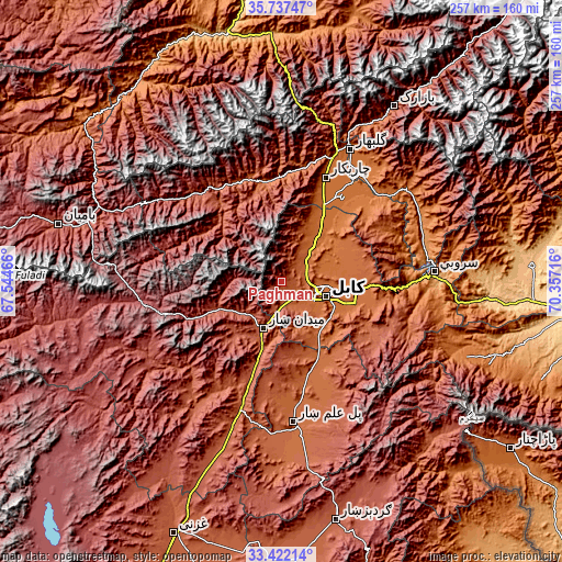
| \ | Map #1 | Map #2 | Topo.Map |
| Scale [m] | 2052..3296 m | 1908..4363 m | × |
| Scale [ft] | 6732..10814 ft | 6260..14314 ft | × |
| Average | 2420.7 m = 7942 ft | 2545.9 m = 8353 ft | × |
| Width | 8.05 km = 5 mi | 16.09 km = 10 mi | 257.4 km = 159.9 mi |
| Height | 8.05 km = 5 mi | 16.09 km = 10 mi | 257.4 km = 159.9 mi |
| ↑Max Latitude | 34.62404° | 34.660195° | 35.73747° |
| Latitude at center | 34.58787° | 34.58787° | 34.58787° |
| ↓Min Latitude | 34.551684° | 34.515482° | 33.42214° |
| ← Min Longitude | 68.906965° | 68.863019° | 67.54466° |
| Longitude center | 68.95091° | 68.95091° | 68.95091° |
| →Max Longitude | 68.994855° | 69.038801° | 70.35716° |
Nearby cities:
Cities around Paghmān sort by population:
• Kabul elevation 1798 m
21.3 km,  108°
108°
• Mīr Bachah Kōṯ 1673 m
23.7 km,  40°
40°
• Maydanshakhr 2206 m
22.7 km,  199°
199°
• Jalrēz 2347 m
30.1 km,  244°
244°
• Istālif 1891 m
29.6 km,  23°
23°
• Qal‘ah-ye Na‘īm 1819 m
28.8 km,  136°
136°
• Kalakān 1593 m
28.4 km, 39°
• Pul-e Sangī 1776 m
28.3 km,  87°
87°
• Zargarān 1935 m
24.3 km, 23°
• Deh-e Now 1974 m
19.9 km,  26°
26°
• Surkh Bilandī 2040 m
12.9 km, 33°
• Chandal Bā’ī 2304 m
0.5 km,  131°
131°
Multilingual:
 En español:
Paghmān elevación 2328 m.
 En France:
Paghmān élévation 2328 m.
 Auf Deutsch:
Paghmān höhe über dem Meeresspiegel ist 2328 m.

Sources and notes:
- [note 1] Map square and city borders are not equal. Map elevation data is calculated only from area inside that square.
- [src 1] Elevation data from geonames database provided with same terms of usage.
- [src 2] The elevation map of Paghmān is generated using elevation data from NASA's 3 arcsec (90m) resolution SRTM data.
- [src 3] Base (background) map © OpenStreetMap contributors tiles are generated by Geofabrik and OpenTopoMap.
Copyright & License:
This Paghmān Elevation Map is licensed under CC BY-SA. You may reuse any part from this page, if you give a proper credit by linking to this URL:
 More info on terms of use page.