Mīr Bachah Kōṯ elevation
Mīr Bachah Kōṯ (Kabul), Afghanistan elevation is 1673 meters and Mīr Bachah Kōṯ elevation in feet is 5489 ft above sea level [src 1]. Mīr Bachah Kōṯ is a seat of a second-order administrative division (feature code) with elevation that is 254 meters (833 ft) bigger than average city elevation in Afghanistan.
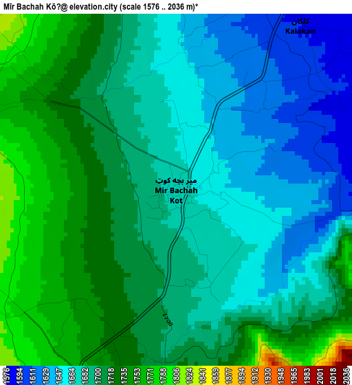
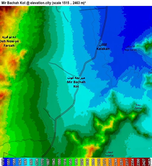
Below is the Elevation map of Mīr Bachah Kōṯ, which displays elevation range with different colors. Scale of the first map is from 1576 to 2036 m (5171 to 6680 ft) with average elevation of 1694.8 meters (=5560 ft) [note 1]
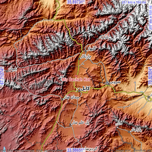
These maps also provides idea of topography and contour of this city, they are displayed at different zoom levels. More info about maps, scale and edge coordinates you can find below images.
| \ | Map #1 | Map #2 | Topo.Map |
| Scale [m] | 1576..2036 m | 1515..2463 m | × |
| Scale [ft] | 5171..6680 ft | 4970..8081 ft | × |
| Average | 1694.8 m = 5560 ft | 1768 m = 5801 ft | × |
| Width | 8.03 km = 5 mi | 16.06 km = 10 mi | 256.9 km = 159.6 mi |
| Height | 8.03 km = 5 mi | 16.06 km = 10 mi | 256.9 km = 159.6 mi |
| ↑Max Latitude | 34.78609° | 34.822173° | 35.89731° |
| Latitude at center | 34.74999° | 34.74999° | 34.74999° |
| ↓Min Latitude | 34.713875° | 34.677743° | 33.58651° |
| ← Min Longitude | 69.075045° | 69.031099° | 67.71274° |
| Longitude center | 69.11899° | 69.11899° | 69.11899° |
| →Max Longitude | 69.162935° | 69.206881° | 70.52524° |
Nearby cities:
Cities around Mīr Bachah Kōṯ sort by population:
• Kabul elevation 1798 m
25.1 km,  168°
168°
• Charikar 1554 m
29.7 km,  9°
9°
• Paghmān 2328 m
23.7 km,  220°
220°
• Ghulām ‘Alī 1489 m
24.5 km,  24°
24°
• Chandal Bā’ī 2304 m
23.7 km, 219°
• Pul-e Sangī 1776 m
21.1 km,  142°
142°
• Qarah Bāgh Bāzār 1531 m
12.4 km, 22°
• Surkh Bilandī 2040 m
11 km,  228°
228°
• Istālif 1891 m
9.9 km,  337°
337°
• Zargarān 1935 m
6.9 km,  307°
307°
• Deh-e Now 1974 m
6.5 km,  267°
267°
• Kalakān 1593 m
4.7 km,  37°
37°
Multilingual:
 En español:
Mīr Bachah Kōṯ elevación 1673 m.
 En France:
Mīr Bachah Kōṯ élévation 1673 m.
 Auf Deutsch:
Mīr Bachah Kōṯ höhe über dem Meeresspiegel ist 1673 m.

Sources and notes:
- [note 1] Map square and city borders are not equal. Map elevation data is calculated only from area inside that square.
- [src 1] Elevation data from geonames database provided with same terms of usage.
- [src 2] The elevation map of Mīr Bachah Kōṯ is generated using elevation data from NASA's 3 arcsec (90m) resolution SRTM data.
- [src 3] Base (background) map © OpenStreetMap contributors tiles are generated by Geofabrik and OpenTopoMap.
Copyright & License:
This Mīr Bachah Kōṯ Elevation Map is licensed under CC BY-SA. You may reuse any part from this page, if you give a proper credit by linking to this URL:
 More info on terms of use page.