Charikar elevation
Charikar (Parwan, Chārīkār), Afghanistan elevation is 1554 meters and Charikar elevation in feet is 5098 ft above sea level [src 1]. Charikar is a seat of a first-order administrative division (feature code) with elevation that is 135 meters (443 ft) bigger than average city elevation in Afghanistan.
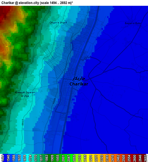
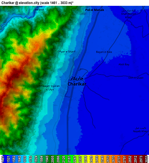
Below is the Elevation map of Charikar, which displays elevation range with different colors. Scale of the first map is from 1494 to 2692 m (4902 to 8832 ft) with average elevation of 1645.8 meters (=5400 ft) [note 1]
These maps also provides idea of topography and contour of this city, they are displayed at different zoom levels. More info about maps, scale and edge coordinates you can find below images.
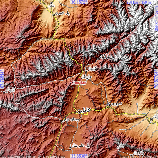
| \ | Map #1 | Map #2 | Topo.Map |
| Scale [m] | 1494..2692 m | 1461..3033 m | × |
| Scale [ft] | 4902..8832 ft | 4793..9951 ft | × |
| Average | 1645.8 m = 5400 ft | 1754.9 m = 5758 ft | × |
| Width | 8 km = 5 mi | 16.01 km = 9.9 mi | 256.1 km = 159.1 mi |
| Height | 8 km = 5 mi | 16.01 km = 9.9 mi | 256.1 km = 159.1 mi |
| ↑Max Latitude | 35.049594° | 35.085562° | 36.1572° |
| Latitude at center | 35.01361° | 35.01361° | 35.01361° |
| ↓Min Latitude | 34.97761° | 34.941595° | 33.8538° |
| ← Min Longitude | 69.127445° | 69.083499° | 67.76514° |
| Longitude center | 69.17139° | 69.17139° | 69.17139° |
| →Max Longitude | 69.215335° | 69.259281° | 70.57764° |
Nearby cities:
Cities around Charikar sort by population:
• Jabal os Saraj elevation 1612 m
13.1 km,  27°
27°
• Sidqābād 1486 m
16.4 km,  86°
86°
• Siyāhgird 1878 m
28.8 km,  268°
268°
• Zargarān 1935 m
27.1 km,  202°
202°
• Ḩājī Khēl 1914 m
26.1 km,  65°
65°
• Kalakān 1593 m
25.6 km,  184°
184°
• Bāgh-e Maīdān 1988 m
23.4 km,  9°
9°
• Istālif 1891 m
21.9 km, 203°
• Qarah Bāgh Bāzār 1531 m
17.9 km, 180°
• Qāshqāl 1733 m
15.3 km,  280°
280°
• Ibrāhīm Khān 1491 m
8.9 km,  60°
60°
• Ghulām ‘Alī 1489 m
8.7 km,  143°
143°
Multilingual:
 En español:
Charikar elevación 1554 m.
 En France:
Charikar élévation 1554 m.
 Auf Deutsch:
Tscharikar höhe über dem Meeresspiegel ist 1554 m.

Sources and notes:
- [note 1] Map square and city borders are not equal. Map elevation data is calculated only from area inside that square.
- [src 1] Elevation data from geonames database provided with same terms of usage.
- [src 2] The elevation map of Charikar is generated using elevation data from NASA's 3 arcsec (90m) resolution SRTM data.
- [src 3] Base (background) map © OpenStreetMap contributors tiles are generated by Geofabrik and OpenTopoMap.
Copyright & License:
This Charikar Elevation Map is licensed under CC BY-SA. You may reuse any part from this page, if you give a proper credit by linking to this URL:
 More info on terms of use page.