La‘l elevation
La‘l (Ghowr, La‘l wa Sar Jangal), Afghanistan elevation is 2797 meters and La‘l elevation in feet is 9177 ft above sea level [src 1]. La‘l is a seat of a second-order administrative division (feature code) with elevation that is 1378 meters (4521 ft) bigger than average city elevation in Afghanistan.
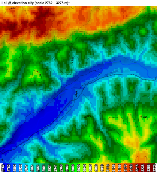
Below is the Elevation map of La‘l, which displays elevation range with different colors. Scale of the first map is from 2762 to 3278 m (9062 to 10755 ft) with average elevation of 2944.2 meters (=9659 ft) [note 1]
These maps also provides idea of topography and contour of this city, they are displayed at different zoom levels. More info about maps, scale and edge coordinates you can find below images.
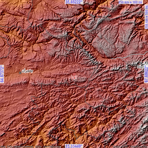
| \ | Map #1 | Topo.Map |
| Scale [m] | 2762..3278 m | × |
| Scale [ft] | 9062..10755 ft | × |
| Average | 2944.2 m = 9659 ft | × |
| Width | 8.05 km = 5 mi | 257.7 km = 160.1 mi |
| Height | 8.05 km = 5 mi | 257.7 km = 160.1 mi |
| ↑Max Latitude | 34.537618° | 35.65222° |
| Latitude at center | 34.50141° | 34.50141° |
| ↓Min Latitude | 34.465186° | 33.33449° |
| ← Min Longitude | 66.236025° | 64.87372° |
| Longitude center | 66.27997° | 66.27997° |
| →Max Longitude | 66.323915° | 67.68622° |
Nearby cities:
Cities around La‘l sort by population:
• Fayrōz Kōh elevation 2263 m
94.3 km,  271°
271°
• Panjāb 2728 m
69.3 km,  100°
100°
• Chīras 2691 m
105.3 km,  345°
345°
• Larkird 1508 m
115.3 km,  17°
17°
• Qal‘ah-ye Shahr 2136 m
133.2 km,  330°
330°
• Chowṉêy 1347 m
124.4 km,  180°
180°
• Sar-e Tayghān 1423 m
123.5 km,  206°
206°
• Nīlī 2069 m
87.8 km,  189°
189°
• Khadīr 2462 m
71.8 km, 206°
• Nayak 2554 m
66.8 km,  67°
67°
• Quchanghī 2456 m
48.9 km, 180°
• Dowlatyār 2456 m
45 km,  277°
277°
Multilingual:
 En español:
La‘l elevación 2797 m.
 En France:
La‘l élévation 2797 m.


Sources and notes:
- [note 1] Map square and city borders are not equal. Map elevation data is calculated only from area inside that square.
- [src 1] Elevation data from geonames database provided with same terms of usage.
- [src 2] The elevation map of La‘l is generated using elevation data from NASA's 3 arcsec (90m) resolution SRTM data.
- [src 3] Base (background) map © OpenStreetMap contributors tiles are generated by Geofabrik and OpenTopoMap.
Copyright & License:
This La‘l Elevation Map is licensed under CC BY-SA. You may reuse any part from this page, if you give a proper credit by linking to this URL:
 More info on terms of use page.