Dowlatyār elevation
Dowlatyār (Ghowr), Afghanistan elevation is 2456 meters and Dowlatyār elevation in feet is 8058 ft above sea level [src 1]. Dowlatyār is a seat of a second-order administrative division (feature code) with elevation that is 1037 meters (3402 ft) bigger than average city elevation in Afghanistan.
Below is the Elevation map of Dowlatyār, which displays elevation range with different colors. Scale of the first map is from 2428 to 2799 m (7966 to 9183 ft) with average elevation of 2563.6 meters (=8411 ft) [note 1]
These maps also provides idea of topography and contour of this city, they are displayed at different zoom levels. More info about maps, scale and edge coordinates you can find below images.
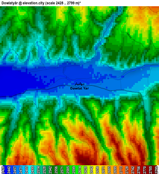
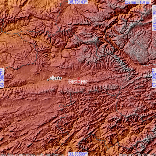
| \ | Map #1 | Topo.Map |
| Scale [m] | 2428..2799 m | × |
| Scale [ft] | 7966..9183 ft | × |
| Average | 2563.6 m = 8411 ft | × |
| Width | 8.05 km = 5 mi | 257.6 km = 160.1 mi |
| Height | 8.05 km = 5 mi | 257.6 km = 160.1 mi |
| ↑Max Latitude | 34.587506° | 35.70143° |
| Latitude at center | 34.55132° | 34.55132° |
| ↓Min Latitude | 34.515118° | 33.38509° |
| ← Min Longitude | 65.749075° | 64.38677° |
| Longitude center | 65.79302° | 65.79302° |
| →Max Longitude | 65.836965° | 67.19927° |
Nearby cities:
Cities around Dowlatyār sort by population:
• Fayrōz Kōh elevation 2263 m
49.8 km,  265°
265°
• Panjāb 2728 m
114.2 km,  99°
99°
• Chīras 2691 m
97.8 km,  10°
10°
• Qal‘ah-ye Shahr 2136 m
112.6 km,  349°
349°
• Pasāband 2468 m
129.1 km,  222°
222°
• Sar-e Tayghān 1423 m
116.3 km,  185°
185°
• Nayak 2554 m
108 km,  79°
79°
• Dū Laīnah 2619 m
102.4 km,  244°
244°
• Nīlī 2069 m
97.3 km,  161°
161°
• Khadīr 2462 m
71.1 km,  169°
169°
• Quchanghī 2456 m
70.3 km,  140°
140°
• La‘l 2797 m
45 km, 97°
Multilingual:
 En español:
Dowlatyār elevación 2456 m.
 En France:
Dowlatyār élévation 2456 m.
 Auf Deutsch:
Dowlatyār höhe über dem Meeresspiegel ist 2456 m.

Sources and notes:
- [note 1] Map square and city borders are not equal. Map elevation data is calculated only from area inside that square.
- [src 1] Elevation data from geonames database provided with same terms of usage.
- [src 2] The elevation map of Dowlatyār is generated using elevation data from NASA's 3 arcsec (90m) resolution SRTM data.
- [src 3] Base (background) map © OpenStreetMap contributors tiles are generated by Geofabrik and OpenTopoMap.
Copyright & License:
This Dowlatyār Elevation Map is licensed under CC BY-SA. You may reuse any part from this page, if you give a proper credit by linking to this URL:
 More info on terms of use page.