Fayrōz Kōh elevation
Fayrōz Kōh (Ghowr, Chaghcharān), Afghanistan elevation is 2263 meters and Fayrōz Kōh elevation in feet is 7425 ft above sea level [src 1]. Fayrōz Kōh is a seat of a first-order administrative division (feature code) with elevation that is 844 meters (2769 ft) bigger than average city elevation in Afghanistan.
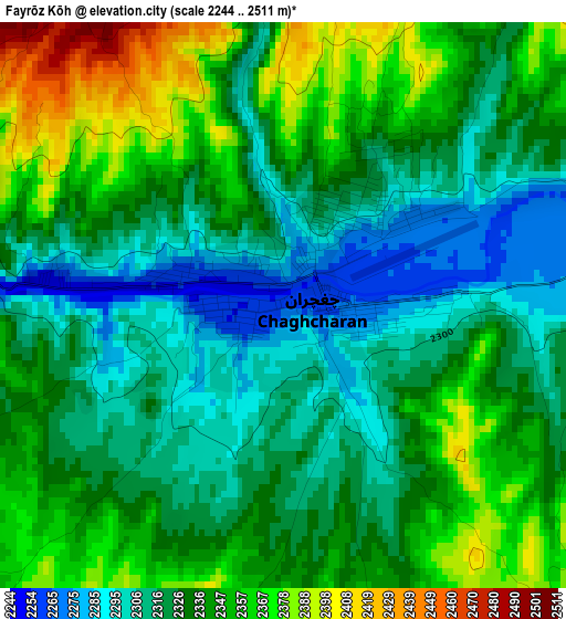
Below is the Elevation map of Fayrōz Kōh, which displays elevation range with different colors. Scale of the first map is from 2244 to 2511 m (7362 to 8238 ft) with average elevation of 2332.7 meters (=7653 ft) [note 1]
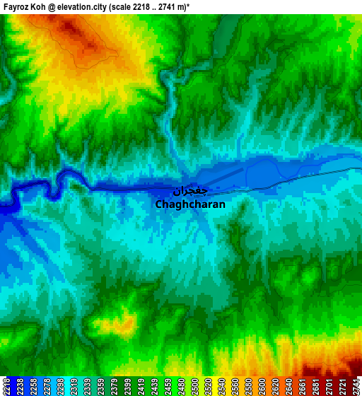
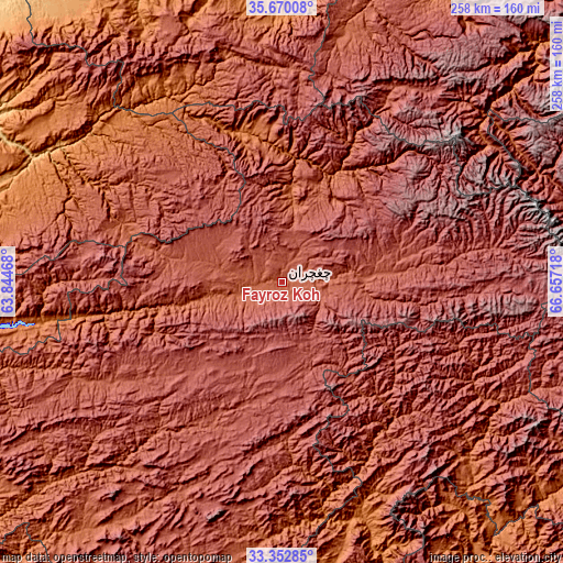
These maps also provides idea of topography and contour of this city, they are displayed at different zoom levels. More info about maps, scale and edge coordinates you can find below images.
| \ | Map #1 | Map #2 | Topo.Map |
| Scale [m] | 2244..2511 m | 2218..2741 m | × |
| Scale [ft] | 7362..8238 ft | 7277..8993 ft | × |
| Average | 2332.7 m = 7653 ft | 2395 m = 7858 ft | × |
| Width | 8.05 km = 5 mi | 16.1 km = 10 mi | 257.7 km = 160.1 mi |
| Height | 8.05 km = 5 mi | 16.1 km = 10 mi | 257.7 km = 160.1 mi |
| ↑Max Latitude | 34.55572° | 34.591905° | 35.67008° |
| Latitude at center | 34.51952° | 34.51952° | 34.51952° |
| ↓Min Latitude | 34.483304° | 34.447073° | 33.35285° |
| ← Min Longitude | 65.206985° | 65.163039° | 63.84468° |
| Longitude center | 65.25093° | 65.25093° | 65.25093° |
| →Max Longitude | 65.294875° | 65.338821° | 66.65718° |
Nearby cities:
Cities around Fayrōz Kōh sort by population:
• Shahrak elevation 2357 m
98.2 km,  242°
242°
• Chīras 2691 m
120 km,  33°
33°
• Qal‘ah-ye Shahr 2136 m
117.9 km,  14°
14°
• Sar-e Tayghān 1423 m
118.9 km,  160°
160°
• Jawand 945 m
117.4 km,  301°
301°
• Quchanghī 2456 m
107.2 km,  118°
118°
• Lāsh 1927 m
104.9 km,  335°
335°
• Pasāband 2468 m
99.3 km,  201°
201°
• La‘l 2797 m
94.3 km,  91°
91°
• Khadīr 2462 m
91.4 km,  136°
136°
• Dū Laīnah 2619 m
58.8 km,  226°
226°
• Dowlatyār 2456 m
49.8 km, 85°
Multilingual:
 En español:
Fayrōz Kōh elevación 2263 m.
 En France:
Fayrōz Kōh élévation 2263 m.
 Auf Deutsch:
Fayrōz Kōh höhe über dem Meeresspiegel ist 2263 m.

Sources and notes:
- [note 1] Map square and city borders are not equal. Map elevation data is calculated only from area inside that square.
- [src 1] Elevation data from geonames database provided with same terms of usage.
- [src 2] The elevation map of Fayrōz Kōh is generated using elevation data from NASA's 3 arcsec (90m) resolution SRTM data.
- [src 3] Base (background) map © OpenStreetMap contributors tiles are generated by Geofabrik and OpenTopoMap.
Copyright & License:
This Fayrōz Kōh Elevation Map is licensed under CC BY-SA. You may reuse any part from this page, if you give a proper credit by linking to this URL:
 More info on terms of use page.