Kenhardt elevation
Kenhardt (Northern Cape, Siyanda District Municipality), South Africa elevation is 805 meters and Kenhardt elevation in feet is 2641 ft above sea level [src 1]. Kenhardt is a populated place (feature code) with elevation that is 167 meters (548 ft) smaller than average city elevation in South Africa.
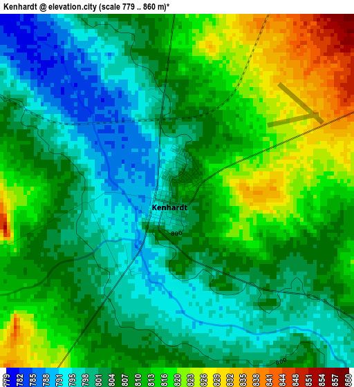
Below is the Elevation map of Kenhardt, which displays elevation range with different colors. Scale of the first map is from 779 to 860 m (2556 to 2822 ft) with average elevation of 807.5 meters (=2649 ft) [note 1]
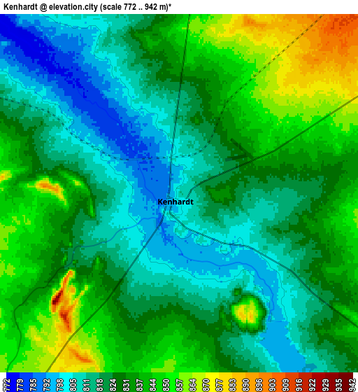
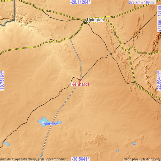
These maps also provides idea of topography and contour of this city, they are displayed at different zoom levels. More info about maps, scale and edge coordinates you can find below images.
| \ | Map #1 | Map #2 | Topo.Map |
| Scale [m] | 779..860 m | 772..942 m | × |
| Scale [ft] | 2556..2822 ft | 2533..3091 ft | × |
| Average | 807.5 m = 2649 ft | 827.8 m = 2716 ft | × |
| Width | 8.52 km = 5.3 mi | 17.04 km = 10.6 mi | 272.6 km = 169.4 mi |
| Height | 8.52 km = 5.3 mi | 17.04 km = 10.6 mi | 272.6 km = 169.4 mi |
| ↑Max Latitude | -29.307427° | -29.269099° | -28.11264° |
| Latitude at center | -29.34574° | -29.34574° | -29.34574° |
| ↓Min Latitude | -29.384039° | -29.422324° | -30.5641° |
| ← Min Longitude | 21.113915° | 21.069969° | 19.75161° |
| Longitude center | 21.15786° | 21.15786° | 21.15786° |
| →Max Longitude | 21.201805° | 21.245751° | 22.56411° |
Nearby cities:
Cities around Kenhardt sort by population:
• Upington elevation 808 m
100.3 km,  5°
5°
• Postmasburg 1305 m
217.2 km,  58°
58°
• Prieska 942 m
157.5 km,  103°
103°
• Kathu 1233 m
260.4 km,  45°
45°
• Carnarvon 1249 m
203.3 km,  152°
152°
• Pofadder 992 m
172.7 km,  278°
278°
• Brandvlei 921 m
140.3 km,  207°
207°
• Van Wyksvlei 962 m
129 km, 150°
• Douglas 992 m
256 km,  82°
82°
• Williston 1078 m
223 km,  185°
185°
• Groblershoop 868 m
94.6 km, 58°
• Kakamas 664 m
82.7 km,  320°
320°
Multilingual:
 En español:
Kenhardt elevación 805 m.
 En France:
Kenhardt élévation 805 m.
 Auf Deutsch:
Kenhardt höhe über dem Meeresspiegel ist 805 m.

Sources and notes:
- [note 1] Map square and city borders are not equal. Map elevation data is calculated only from area inside that square.
- [src 1] Elevation data from geonames database provided with same terms of usage.
- [src 2] The elevation map of Kenhardt is generated using elevation data from NASA's 3 arcsec (90m) resolution SRTM data.
- [src 3] Base (background) map © OpenStreetMap contributors tiles are generated by Geofabrik and OpenTopoMap.
Copyright & License:
This Kenhardt Elevation Map is licensed under CC BY-SA. You may reuse any part from this page, if you give a proper credit by linking to this URL:
 More info on terms of use page.