Kathu elevation
Kathu (Northern Cape, John Taolo Gaetsewe District Municipality), South Africa elevation is 1233 meters and Kathu elevation in feet is 4045 ft above sea level [src 1]. Kathu is a seat of a third-order administrative division (feature code) with elevation that is 261 meters (856 ft) bigger than average city elevation in South Africa.
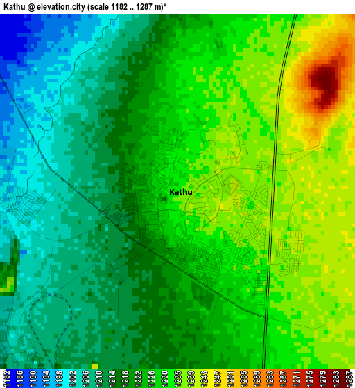
Below is the Elevation map of Kathu, which displays elevation range with different colors. Scale of the first map is from 1182 to 1287 m (3878 to 4222 ft) with average elevation of 1223.3 meters (=4013 ft) [note 1]
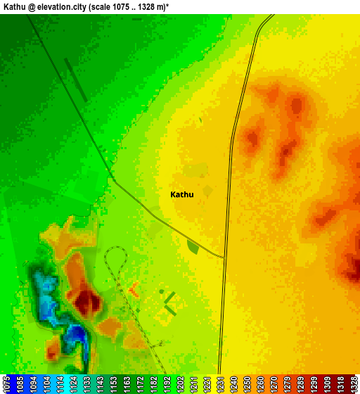
These maps also provides idea of topography and contour of this city, they are displayed at different zoom levels. More info about maps, scale and edge coordinates you can find below images.
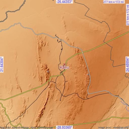
| \ | Map #1 | Map #2 | Topo.Map |
| Scale [m] | 1182..1287 m | 1075..1328 m | × |
| Scale [ft] | 3878..4222 ft | 3527..4357 ft | × |
| Average | 1223.3 m = 4013 ft | 1216.7 m = 3992 ft | × |
| Width | 8.65 km = 5.4 mi | 17.31 km = 10.8 mi | 276.9 km = 172.1 mi |
| Height | 8.65 km = 5.4 mi | 17.31 km = 10.8 mi | 276.9 km = 172.1 mi |
| ↑Max Latitude | -27.656773° | -27.617841° | -26.44353° |
| Latitude at center | -27.69569° | -27.69569° | -27.69569° |
| ↓Min Latitude | -27.734593° | -27.773483° | -28.93365° |
| ← Min Longitude | 23.005345° | 22.961399° | 21.64304° |
| Longitude center | 23.04929° | 23.04929° | 23.04929° |
| →Max Longitude | 23.093235° | 23.137181° | 24.45554° |
Nearby cities:
Cities around Kathu sort by population:
• Postmasburg elevation 1305 m
71 km,  178°
178°
• Pampierstad 1078 m
161.5 km,  93°
93°
• Warrenton 1190 m
182.7 km,  104°
104°
• Jan Kempdorp 1159 m
177 km, 98°
• Barkly West 1104 m
171.9 km,  122°
122°
• Daniëlskuil 1468 m
73 km,  138°
138°
• Kuruman 1323 m
46.5 km,  54°
54°
• Hartswater 1125 m
172.1 km, 91°
• Taung 1118 m
172.1 km,  83°
83°
• Groblershoop 868 m
169.3 km,  218°
218°
• Douglas 992 m
167 km,  154°
154°
• Ganyesa 1282 m
165.5 km,  42°
42°
Multilingual:
 En español:
Kathu elevación 1233 m.
 En France:
Kathu élévation 1233 m.


Sources and notes:
- [note 1] Map square and city borders are not equal. Map elevation data is calculated only from area inside that square.
- [src 1] Elevation data from geonames database provided with same terms of usage.
- [src 2] The elevation map of Kathu is generated using elevation data from NASA's 3 arcsec (90m) resolution SRTM data.
- [src 3] Base (background) map © OpenStreetMap contributors tiles are generated by Geofabrik and OpenTopoMap.
Copyright & License:
This Kathu Elevation Map is licensed under CC BY-SA. You may reuse any part from this page, if you give a proper credit by linking to this URL:
 More info on terms of use page.