Postmasburg elevation
Postmasburg (Northern Cape, Siyanda District Municipality), South Africa elevation is 1305 meters and Postmasburg elevation in feet is 4281 ft above sea level [src 1]. Postmasburg is a seat of a third-order administrative division (feature code) with elevation that is 333 meters (1093 ft) bigger than average city elevation in South Africa.
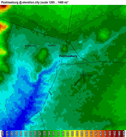
Below is the Elevation map of Postmasburg, which displays elevation range with different colors. Scale of the first map is from 1265 to 1468 m (4150 to 4816 ft) with average elevation of 1323.5 meters (=4342 ft) [note 1]
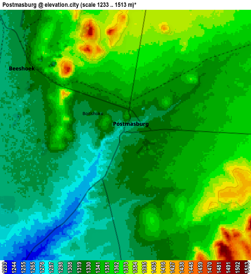
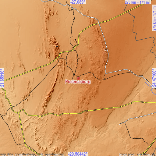
These maps also provides idea of topography and contour of this city, they are displayed at different zoom levels. More info about maps, scale and edge coordinates you can find below images.
| \ | Map #1 | Map #2 | Topo.Map |
| Scale [m] | 1265..1468 m | 1233..1513 m | × |
| Scale [ft] | 4150..4816 ft | 4045..4964 ft | × |
| Average | 1323.5 m = 4342 ft | 1337 m = 4386 ft | × |
| Width | 8.6 km = 5.3 mi | 17.2 km = 10.7 mi | 275.2 km = 171 mi |
| Height | 8.6 km = 5.3 mi | 17.2 km = 10.7 mi | 275.2 km = 171 mi |
| ↑Max Latitude | -28.295232° | -28.256531° | -27.089° |
| Latitude at center | -28.33392° | -28.33392° | -28.33392° |
| ↓Min Latitude | -28.372593° | -28.411253° | -29.56442° |
| ← Min Longitude | 23.021465° | 22.977519° | 21.65916° |
| Longitude center | 23.06541° | 23.06541° | 23.06541° |
| →Max Longitude | 23.109355° | 23.153301° | 24.47166° |
Nearby cities:
Cities around Postmasburg sort by population:
• Kimberley elevation 1224 m
171.6 km,  104°
104°
• Pampierstad 1078 m
170.5 km,  68°
68°
• Warrenton 1190 m
176.3 km,  82°
82°
• Barkly West 1104 m
144.1 km, 98°
• Prieska 942 m
151.6 km,  191°
191°
• Daniëlskuil 1468 m
49.2 km, 70°
• Ritchie 1115 m
169.2 km,  117°
117°
• Kathu 1233 m
71 km,  358°
358°
• Kuruman 1323 m
104.4 km,  20°
20°
• Hopetown 1095 m
174.5 km,  145°
145°
• Groblershoop 868 m
122.6 km,  239°
239°
• Douglas 992 m
105.9 km,  139°
139°
Multilingual:
 En español:
Postmasburg elevación 1305 m.
 En France:
Postmasburg élévation 1305 m.
 Auf Deutsch:
Postmasburg höhe über dem Meeresspiegel ist 1305 m.

Sources and notes:
- [note 1] Map square and city borders are not equal. Map elevation data is calculated only from area inside that square.
- [src 1] Elevation data from geonames database provided with same terms of usage.
- [src 2] The elevation map of Postmasburg is generated using elevation data from NASA's 3 arcsec (90m) resolution SRTM data.
- [src 3] Base (background) map © OpenStreetMap contributors tiles are generated by Geofabrik and OpenTopoMap.
Copyright & License:
This Postmasburg Elevation Map is licensed under CC BY-SA. You may reuse any part from this page, if you give a proper credit by linking to this URL:
 More info on terms of use page.