Ritchie elevation
Ritchie (Northern Cape, Frances Baard District Municipality), South Africa elevation is 1115 meters and Ritchie elevation in feet is 3658 ft above sea level [src 1]. Ritchie is a populated place (feature code) with elevation that is 143 meters (469 ft) bigger than average city elevation in South Africa.
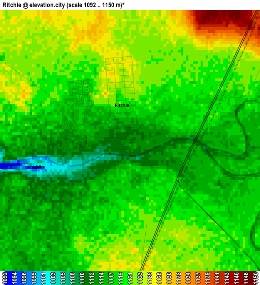
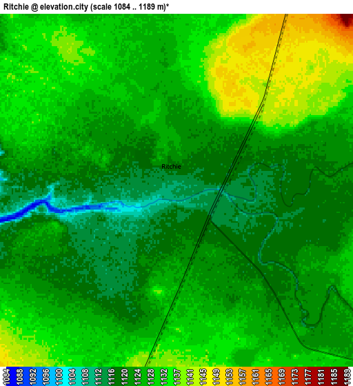
Below is the Elevation map of Ritchie, which displays elevation range with different colors. Scale of the first map is from 1092 to 1150 m (3583 to 3773 ft) with average elevation of 1119.2 meters (=3672 ft) [note 1]
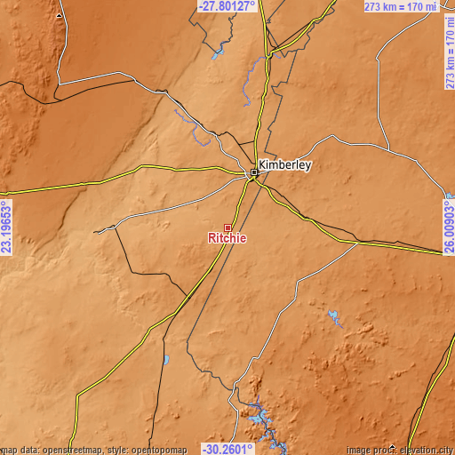
These maps also provides idea of topography and contour of this city, they are displayed at different zoom levels. More info about maps, scale and edge coordinates you can find below images.
| \ | Map #1 | Map #2 | Topo.Map |
| Scale [m] | 1092..1150 m | 1084..1189 m | × |
| Scale [ft] | 3583..3773 ft | 3556..3901 ft | × |
| Average | 1119.2 m = 3672 ft | 1126.4 m = 3696 ft | × |
| Width | 8.54 km = 5.3 mi | 17.09 km = 10.6 mi | 273.4 km = 169.9 mi |
| Height | 8.54 km = 5.3 mi | 17.09 km = 10.6 mi | 273.4 km = 169.9 mi |
| ↑Max Latitude | -28.999582° | -28.961139° | -27.80127° |
| Latitude at center | -29.03801° | -29.03801° | -29.03801° |
| ↓Min Latitude | -29.076424° | -29.114824° | -30.2601° |
| ← Min Longitude | 24.558835° | 24.514889° | 23.19653° |
| Longitude center | 24.60278° | 24.60278° | 24.60278° |
| →Max Longitude | 24.646725° | 24.690671° | 26.00903° |
Nearby cities:
Cities around Ritchie sort by population:
• Kimberley elevation 1224 m
37.4 km,  24°
24°
• Pampierstad 1078 m
139.8 km,  3°
3°
• Warrenton 1190 m
105.5 km,  13°
13°
• Christiana 1207 m
136.4 km, 23°
• Jan Kempdorp 1159 m
126 km, 10°
• Barkly West 1104 m
56.4 km,  351°
351°
• Orania 1111 m
88.2 km,  192°
192°
• Petrusville 1199 m
116.1 km,  177°
177°
• Boshof 1254 m
83.2 km,  48°
48°
• Hopetown 1095 m
82.3 km,  217°
217°
• Douglas 992 m
80.6 km,  268°
268°
• Koffiefontein 1188 m
56.5 km,  136°
136°
Multilingual:
 En español:
Ritchie elevación 1115 m.
 En France:
Ritchie élévation 1115 m.
 Auf Deutsch:
Ritchie höhe über dem Meeresspiegel ist 1115 m.

Sources and notes:
- [note 1] Map square and city borders are not equal. Map elevation data is calculated only from area inside that square.
- [src 1] Elevation data from geonames database provided with same terms of usage.
- [src 2] The elevation map of Ritchie is generated using elevation data from NASA's 3 arcsec (90m) resolution SRTM data.
- [src 3] Base (background) map © OpenStreetMap contributors tiles are generated by Geofabrik and OpenTopoMap.
Copyright & License:
This Ritchie Elevation Map is licensed under CC BY-SA. You may reuse any part from this page, if you give a proper credit by linking to this URL:
 More info on terms of use page.