Electric City elevation
Electric City (Washington, Grant County), United States elevation is 501 meters and Electric City elevation in feet is 1644 ft above sea level [src 1]. Electric City is a populated place (feature code) with elevation that is 222 meters (728 ft) bigger than average city elevation in United States.
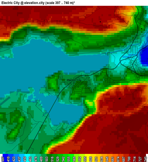
Below is the Elevation map of Electric City, which displays elevation range with different colors. Scale of the first map is from 397 to 740 m (1302 to 2428 ft) with average elevation of 568.3 meters (=1865 ft) [note 1]
These maps also provides idea of topography and contour of this city, they are displayed at different zoom levels. More info about maps, scale and edge coordinates you can find below images.
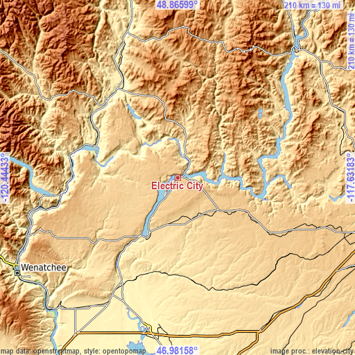
| \ | Map #1 | Topo.Map |
| Scale [m] | 397..740 m | × |
| Scale [ft] | 1302..2428 ft | × |
| Average | 568.3 m = 1865 ft | × |
| Width | 6.55 km = 4.1 mi | 209.5 km = 130.2 mi |
| Height | 6.55 km = 4.1 mi | 209.5 km = 130.2 mi |
| ↑Max Latitude | 47.961805° | 48.86599° |
| Latitude at center | 47.93237° | 47.93237° |
| ↓Min Latitude | 47.902918° | 46.98158° |
| ← Min Longitude | -119.082025° | -120.44433° |
| Longitude center | -119.03808° | -119.03808° |
| →Max Longitude | -118.994135° | -117.63183° |
Nearby cities:
Cities around Electric City sort by population:
• Ephrata elevation 387 m
78.5 km,  209°
209°
• Omak 255 m
64.4 km,  325°
325°
• Chelan 343 m
73.7 km,  262°
262°
• Okanogan 255 m
62.5 km,  319°
319°
• Bridgeport 258 m
47.9 km,  280°
280°
• Brewster 243 m
58.1 km,  288°
288°
• Davenport 723 m
73.2 km,  115°
115°
• Soap Lake 336 m
69.2 km, 209°
• Waterville 798 m
83.4 km,  247°
247°
• Coulee Dam 349 m
5.9 km,  51°
51°
• Republic 782 m
82.6 km,  15°
15°
• Grand Coulee 446 m
2.8 km,  68°
68°
Multilingual:
 En español:
Electric City elevación 501 m.
 En France:
Electric City élévation 501 m.
 Auf Deutsch:
Electric City höhe über dem Meeresspiegel ist 501 m.

Sources and notes:
- [note 1] Map square and city borders are not equal. Map elevation data is calculated only from area inside that square.
- [src 1] Elevation data from geonames database provided with same terms of usage.
- [src 2] The elevation map of Electric City is generated using elevation data from NASA's 3 arcsec (90m) resolution SRTM data.
- [src 3] Base (background) map © OpenStreetMap contributors tiles are generated by Geofabrik and OpenTopoMap.
Copyright & License:
This Electric City Elevation Map is licensed under CC BY-SA. You may reuse any part from this page, if you give a proper credit by linking to this URL:
 More info on terms of use page.