Waterville elevation
Waterville (Washington, Douglas County), United States elevation is 798 meters and Waterville elevation in feet is 2618 ft above sea level [src 1]. Waterville is a seat of a second-order administrative division (feature code) with elevation that is 519 meters (1703 ft) bigger than average city elevation in United States.
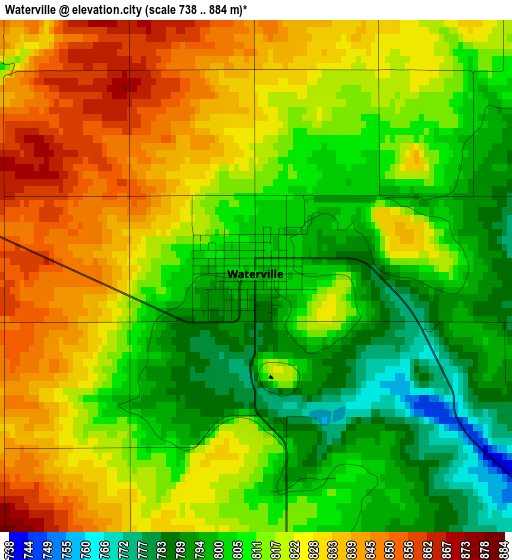
Below is the Elevation map of Waterville, which displays elevation range with different colors. Scale of the first map is from 738 to 884 m (2421 to 2900 ft) with average elevation of 815.5 meters (=2676 ft) [note 1]
These maps also provides idea of topography and contour of this city, they are displayed at different zoom levels. More info about maps, scale and edge coordinates you can find below images.
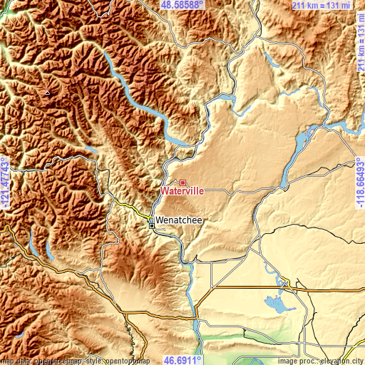
| \ | Map #1 | Topo.Map |
| Scale [m] | 738..884 m | × |
| Scale [ft] | 2421..2900 ft | × |
| Average | 815.5 m = 2676 ft | × |
| Width | 6.58 km = 4.1 mi | 210.7 km = 130.9 mi |
| Height | 6.58 km = 4.1 mi | 210.7 km = 130.9 mi |
| ↑Max Latitude | 47.676677° | 48.58588° |
| Latitude at center | 47.64708° | 47.64708° |
| ↓Min Latitude | 47.617466° | 46.6911° |
| ← Min Longitude | -120.115125° | -121.47743° |
| Longitude center | -120.07118° | -120.07118° |
| →Max Longitude | -120.027235° | -118.66493° |
Nearby cities:
Cities around Waterville sort by population:
• Wenatchee elevation 201 m
30.7 km,  215°
215°
• East Wenatchee 206 m
30.7 km,  212°
212°
• East Wenatchee Bench 280 m
29.2 km, 212°
• Chelan 343 m
21.9 km,  10°
10°
• Sunnyslope 246 m
27.8 km,  225°
225°
• Cashmere 240 m
33 km,  245°
245°
• Granite Falls 341 m
29 km,  338°
338°
• Leavenworth 356 m
44.6 km,  262°
262°
• West Wenatchee 264 m
31 km, 223°
• South Wenatchee 195 m
32.9 km, 209°
• Manson 345 m
27.2 km,  346°
346°
• Entiat 231 m
10.8 km,  287°
287°
Multilingual:
 En español:
Waterville elevación 798 m.
 En France:
Waterville élévation 798 m.
 Auf Deutsch:
Waterville höhe über dem Meeresspiegel ist 798 m.

Sources and notes:
- [note 1] Map square and city borders are not equal. Map elevation data is calculated only from area inside that square.
- [src 1] Elevation data from geonames database provided with same terms of usage.
- [src 2] The elevation map of Waterville is generated using elevation data from NASA's 3 arcsec (90m) resolution SRTM data.
- [src 3] Base (background) map © OpenStreetMap contributors tiles are generated by Geofabrik and OpenTopoMap.
Copyright & License:
This Waterville Elevation Map is licensed under CC BY-SA. You may reuse any part from this page, if you give a proper credit by linking to this URL:
 More info on terms of use page.