Omak elevation
Omak (Washington, Okanogan County), United States elevation is 255 meters and Omak elevation in feet is 837 ft above sea level [src 1]. Omak is a populated place (feature code) with elevation that is 24 meters (79 ft) smaller than average city elevation in United States.
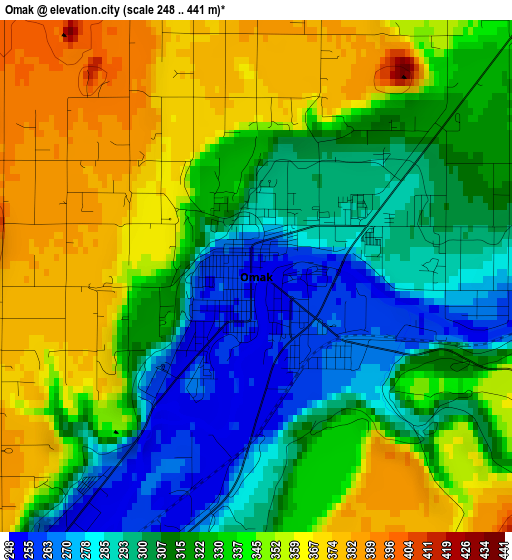
Below is the Elevation map of Omak, which displays elevation range with different colors. Scale of the first map is from 248 to 441 m (814 to 1447 ft) with average elevation of 326.8 meters (=1072 ft) [note 1]
These maps also provides idea of topography and contour of this city, they are displayed at different zoom levels. More info about maps, scale and edge coordinates you can find below images.
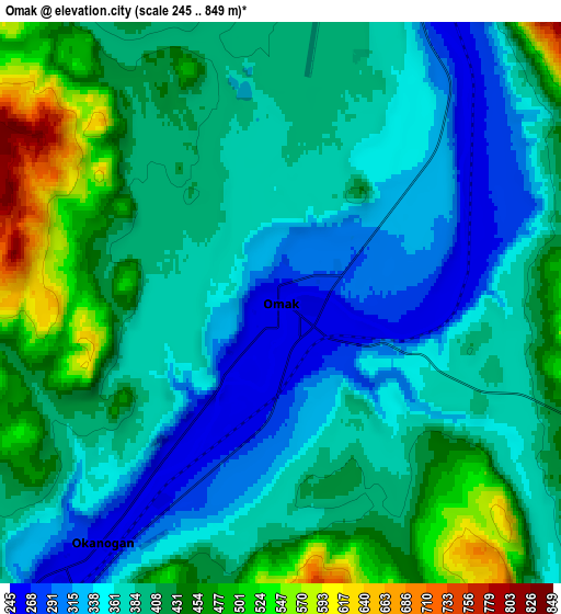
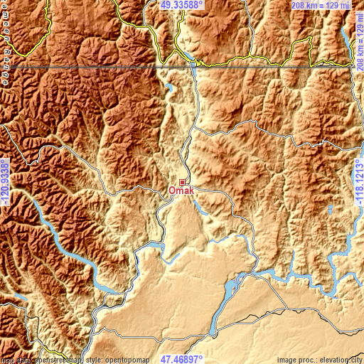
| \ | Map #1 | Map #2 | Topo.Map |
| Scale [m] | 248..441 m | 245..849 m | × |
| Scale [ft] | 814..1447 ft | 804..2785 ft | × |
| Average | 326.8 m = 1072 ft | 396.1 m = 1300 ft | × |
| Width | 6.49 km = 4 mi | 12.97 km = 8.1 mi | 207.6 km = 129 mi |
| Height | 6.49 km = 4 mi | 12.97 km = 8.1 mi | 207.6 km = 129 mi |
| ↑Max Latitude | 48.440152° | 48.469297° | 49.33588° |
| Latitude at center | 48.41099° | 48.41099° | 48.41099° |
| ↓Min Latitude | 48.381811° | 48.352616° | 47.46897° |
| ← Min Longitude | -119.571495° | -119.615441° | -120.9338° |
| Longitude center | -119.52755° | -119.52755° | -119.52755° |
| →Max Longitude | -119.483605° | -119.439659° | -118.1213° |
Nearby cities:
Cities around Omak sort by population:
• Chelan elevation 343 m
73 km,  209°
209°
• Granite Falls 341 m
77.1 km,  221°
221°
• Okanogan 255 m
6.9 km, 216°
• Bridgeport 258 m
46 km,  193°
193°
• Brewster 243 m
39.7 km, 208°
• Oroville 281 m
59.1 km,  6°
6°
• Manson 345 m
74.9 km, 218°
• Coulee Dam 349 m
64.2 km,  140°
140°
• Republic 782 m
63.9 km,  65°
65°
• Grand Coulee 446 m
65.1 km, 143°
• Tonasket 277 m
33.3 km, 11°
• Electric City 501 m
64.4 km,  145°
145°
Multilingual:
 En español:
Omak elevación 255 m.
 En France:
Omak élévation 255 m.


Sources and notes:
- [note 1] Map square and city borders are not equal. Map elevation data is calculated only from area inside that square.
- [src 1] Elevation data from geonames database provided with same terms of usage.
- [src 2] The elevation map of Omak is generated using elevation data from NASA's 3 arcsec (90m) resolution SRTM data.
- [src 3] Base (background) map © OpenStreetMap contributors tiles are generated by Geofabrik and OpenTopoMap.
Copyright & License:
This Omak Elevation Map is licensed under CC BY-SA. You may reuse any part from this page, if you give a proper credit by linking to this URL:
 More info on terms of use page.