Ephrata elevation
Ephrata (Washington, Grant County), United States elevation is 387 meters and Ephrata elevation in feet is 1270 ft above sea level [src 1]. Ephrata is a seat of a second-order administrative division (feature code) with elevation that is 108 meters (354 ft) bigger than average city elevation in United States.
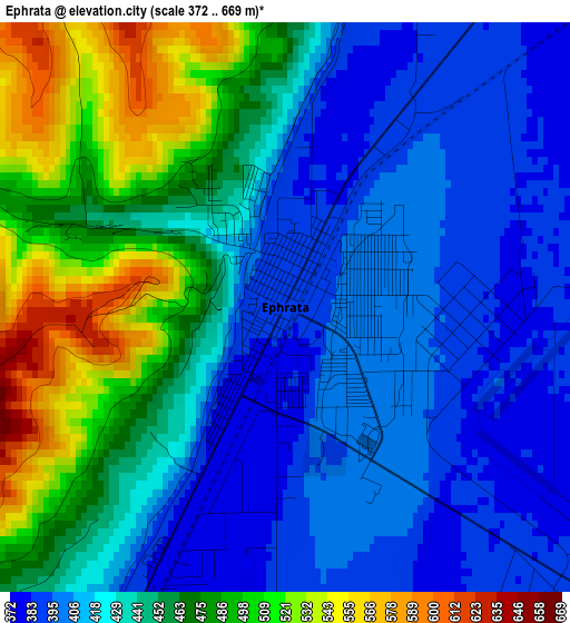
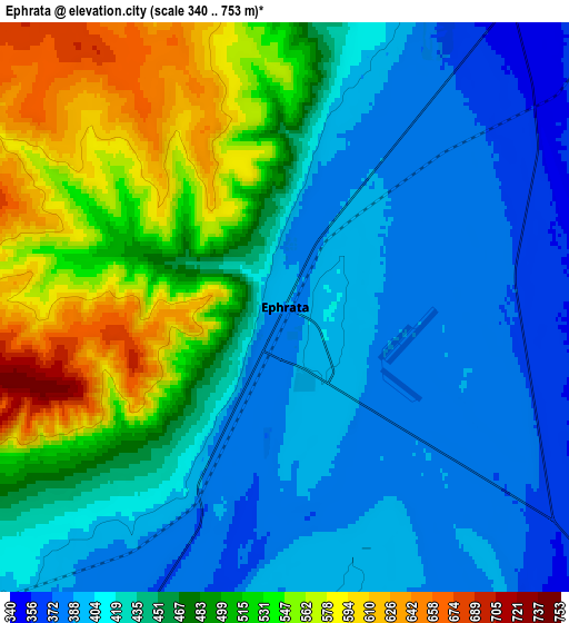
Below is the Elevation map of Ephrata, which displays elevation range with different colors. Scale of the first map is from 372 to 669 m (1220 to 2195 ft) with average elevation of 440.2 meters (=1444 ft) [note 1]
These maps also provides idea of topography and contour of this city, they are displayed at different zoom levels. More info about maps, scale and edge coordinates you can find below images.
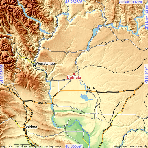
| \ | Map #1 | Map #2 | Topo.Map |
| Scale [m] | 372..669 m | 340..753 m | × |
| Scale [ft] | 1220..2195 ft | 1115..2470 ft | × |
| Average | 440.2 m = 1444 ft | 457.5 m = 1501 ft | × |
| Width | 6.63 km = 4.1 mi | 13.25 km = 8.2 mi | 212 km = 131.7 mi |
| Height | 6.63 km = 4.1 mi | 13.25 km = 8.2 mi | 212 km = 131.7 mi |
| ↑Max Latitude | 47.347424° | 47.37719° | 48.26239° |
| Latitude at center | 47.31764° | 47.31764° | 47.31764° |
| ↓Min Latitude | 47.28784° | 47.258022° | 46.35569° |
| ← Min Longitude | -119.597595° | -119.641541° | -120.9599° |
| Longitude center | -119.55365° | -119.55365° | -119.55365° |
| →Max Longitude | -119.509705° | -119.465759° | -118.1474° |
Nearby cities:
Cities around Ephrata sort by population:
• Wenatchee elevation 201 m
58.2 km,  281°
281°
• Moses Lake 325 m
29.5 km,  135°
135°
• East Wenatchee 206 m
56.7 km, 281°
• East Wenatchee Bench 280 m
56.1 km, 282°
• Quincy 395 m
24.4 km,  247°
247°
• Moses Lake North 354 m
22.5 km,  127°
127°
• Warden 396 m
55 km, 135°
• Cascade Valley 323 m
26.5 km, 140°
• Royal City 323 m
46.7 km,  187°
187°
• Soap Lake 336 m
9.3 km,  30°
30°
• South Wenatchee 195 m
56 km, 278°
• Waterville 798 m
53.4 km,  313°
313°
Multilingual:
 En español:
Ephrata elevación 387 m.
 En France:
Ephrata élévation 387 m.


Sources and notes:
- [note 1] Map square and city borders are not equal. Map elevation data is calculated only from area inside that square.
- [src 1] Elevation data from geonames database provided with same terms of usage.
- [src 2] The elevation map of Ephrata is generated using elevation data from NASA's 3 arcsec (90m) resolution SRTM data.
- [src 3] Base (background) map © OpenStreetMap contributors tiles are generated by Geofabrik and OpenTopoMap.
Copyright & License:
This Ephrata Elevation Map is licensed under CC BY-SA. You may reuse any part from this page, if you give a proper credit by linking to this URL:
 More info on terms of use page.