Cascade Valley elevation
Cascade Valley (Washington, Grant County), United States elevation is 323 meters and Cascade Valley elevation in feet is 1060 ft above sea level [src 1]. Cascade Valley is a populated place (feature code) with elevation that is 44 meters (144 ft) bigger than average city elevation in United States.
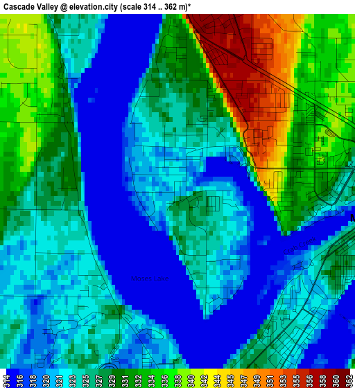
Below is the Elevation map of Cascade Valley, which displays elevation range with different colors. Scale of the first map is from 314 to 362 m (1030 to 1188 ft) with average elevation of 326.5 meters (=1071 ft) [note 1]
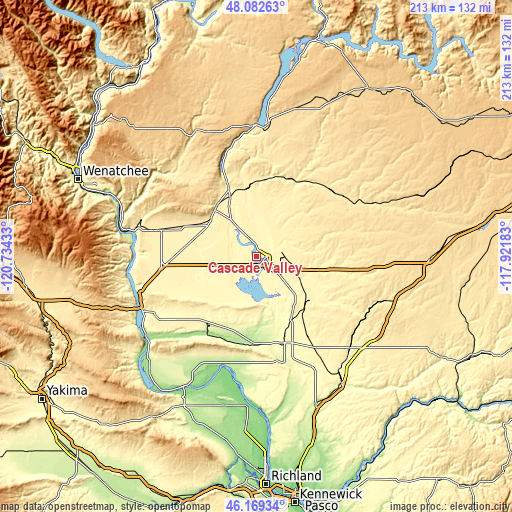
These maps also provides idea of topography and contour of this city, they are displayed at different zoom levels. More info about maps, scale and edge coordinates you can find below images.
| \ | Map #1 | Topo.Map |
| Scale [m] | 314..362 m | × |
| Scale [ft] | 1030..1188 ft | × |
| Average | 326.5 m = 1071 ft | × |
| Width | 6.65 km = 4.1 mi | 212.7 km = 132.2 mi |
| Height | 6.65 km = 4.1 mi | 212.7 km = 132.2 mi |
| ↑Max Latitude | 47.164477° | 48.08263° |
| Latitude at center | 47.13459° | 47.13459° |
| ↓Min Latitude | 47.104687° | 46.16934° |
| ← Min Longitude | -119.372025° | -120.73433° |
| Longitude center | -119.32808° | -119.32808° |
| →Max Longitude | -119.284135° | -117.92183° |
Nearby cities:
Cities around Cascade Valley sort by population:
• Moses Lake elevation 325 m
3.8 km,  97°
97°
• Ephrata 387 m
26.5 km,  320°
320°
• Othello 319 m
36.2 km,  161°
161°
• Quincy 395 m
41.2 km,  285°
285°
• Connell 255 m
63.3 km,  145°
145°
• Mattawa 231 m
62 km,  224°
224°
• Moses Lake North 354 m
6.7 km,  7°
7°
• Warden 396 m
28.7 km,  130°
130°
• Royal City 323 m
34.7 km, 221°
• Desert Aire 170 m
67.6 km, 221°
• Soap Lake 336 m
30.9 km,  336°
336°
• Basin City 211 m
61.6 km,  167°
167°
Multilingual:
 En español:
Cascade Valley elevación 323 m.
 En France:
Cascade Valley élévation 323 m.
 Auf Deutsch:
Cascade Valley höhe über dem Meeresspiegel ist 323 m.

Sources and notes:
- [note 1] Map square and city borders are not equal. Map elevation data is calculated only from area inside that square.
- [src 1] Elevation data from geonames database provided with same terms of usage.
- [src 2] The elevation map of Cascade Valley is generated using elevation data from NASA's 3 arcsec (90m) resolution SRTM data.
- [src 3] Base (background) map © OpenStreetMap contributors tiles are generated by Geofabrik and OpenTopoMap.
Copyright & License:
This Cascade Valley Elevation Map is licensed under CC BY-SA. You may reuse any part from this page, if you give a proper credit by linking to this URL:
 More info on terms of use page.