Sheridan elevation
Sheridan (Oregon, Yamhill County), United States elevation is 56 meters and Sheridan elevation in feet is 184 ft above sea level [src 1]. Sheridan is a populated place (feature code) with elevation that is 223 meters (732 ft) smaller than average city elevation in United States.
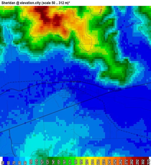
Below is the Elevation map of Sheridan, which displays elevation range with different colors. Scale of the first map is from 50 to 312 m (164 to 1024 ft) with average elevation of 99.1 meters (=325 ft) [note 1]
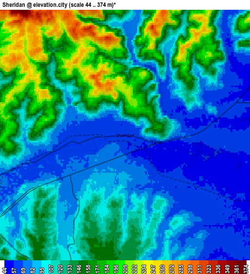
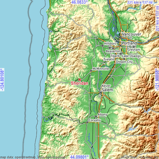
These maps also provides idea of topography and contour of this city, they are displayed at different zoom levels. More info about maps, scale and edge coordinates you can find below images.
| \ | Map #1 | Map #2 | Topo.Map |
| Scale [m] | 50..312 m | 44..374 m | × |
| Scale [ft] | 164..1024 ft | 144..1227 ft | × |
| Average | 99.1 m = 325 ft | 120.1 m = 394 ft | × |
| Width | 6.9 km = 4.3 mi | 13.8 km = 8.6 mi | 220.7 km = 137.1 mi |
| Height | 6.9 km = 4.3 mi | 13.8 km = 8.6 mi | 220.7 km = 137.1 mi |
| ↑Max Latitude | 45.130292° | 45.161287° | 46.0833° |
| Latitude at center | 45.09928° | 45.09928° | 45.09928° |
| ↓Min Latitude | 45.068251° | 45.037206° | 44.09801° |
| ← Min Longitude | -123.438775° | -123.482721° | -124.80108° |
| Longitude center | -123.39483° | -123.39483° | -123.39483° |
| →Max Longitude | -123.350885° | -123.306939° | -121.98858° |
Nearby cities:
Cities around Sheridan sort by population:
• Keizer elevation 42 m
31.4 km,  112°
112°
• McMinnville 48 m
19.7 km,  51°
51°
• Dallas 101 m
20.9 km,  163°
163°
• Monmouth 63 m
30.6 km, 155°
• Independence 52 m
32.1 km,  149°
149°
• Lafayette 52 m
27.2 km, 53°
• Dayton 51 m
28.4 km,  61°
61°
• Willamina 70 m
7.5 km,  252°
252°
• Carlton 62 m
27.6 km,  38°
38°
• Grand Ronde 105 m
17.4 km,  255°
255°
• Amity 56 m
14.8 km,  82°
82°
• Yamhill 60 m
31.5 km,  31°
31°
Multilingual:
 En español:
Sheridan elevación 56 m.
 En France:
Sheridan élévation 56 m.


Sources and notes:
- [note 1] Map square and city borders are not equal. Map elevation data is calculated only from area inside that square.
- [src 1] Elevation data from geonames database provided with same terms of usage.
- [src 2] The elevation map of Sheridan is generated using elevation data from NASA's 3 arcsec (90m) resolution SRTM data.
- [src 3] Base (background) map © OpenStreetMap contributors tiles are generated by Geofabrik and OpenTopoMap.
Copyright & License:
This Sheridan Elevation Map is licensed under CC BY-SA. You may reuse any part from this page, if you give a proper credit by linking to this URL:
 More info on terms of use page.