Yamhill elevation
Yamhill (Oregon, Yamhill County), United States elevation is 60 meters and Yamhill elevation in feet is 197 ft above sea level [src 1]. Yamhill is a populated place (feature code) with elevation that is 219 meters (719 ft) smaller than average city elevation in United States.
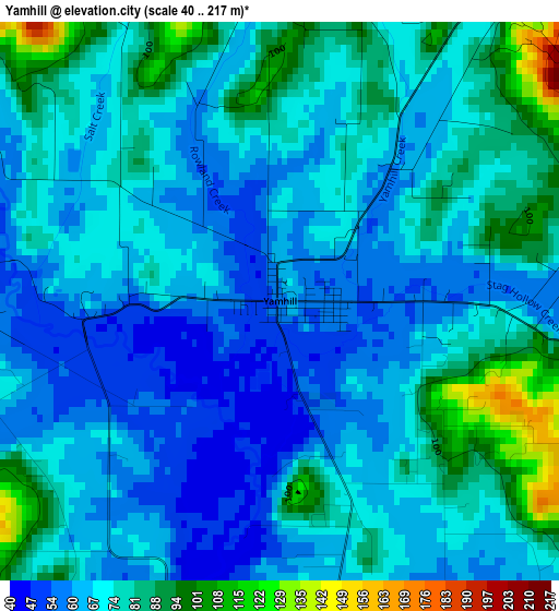
Below is the Elevation map of Yamhill, which displays elevation range with different colors. Scale of the first map is from 40 to 217 m (131 to 712 ft) with average elevation of 72.1 meters (=237 ft) [note 1]
These maps also provides idea of topography and contour of this city, they are displayed at different zoom levels. More info about maps, scale and edge coordinates you can find below images.
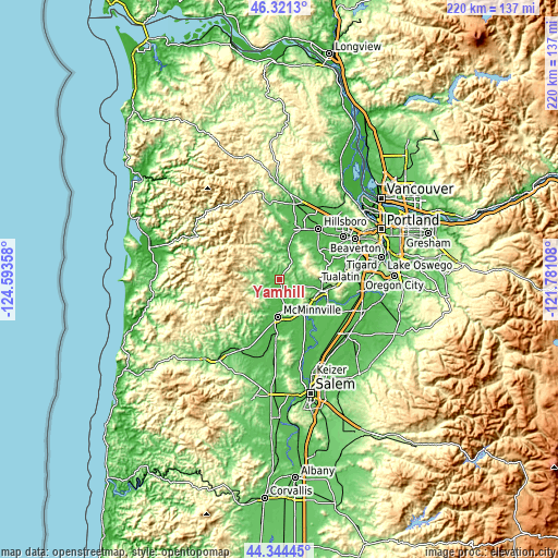
| \ | Map #1 | Topo.Map |
| Scale [m] | 40..217 m | × |
| Scale [ft] | 131..712 ft | × |
| Average | 72.1 m = 237 ft | × |
| Width | 6.87 km = 4.3 mi | 219.8 km = 136.6 mi |
| Height | 6.87 km = 4.3 mi | 219.8 km = 136.6 mi |
| ↑Max Latitude | 45.37238° | 46.3213° |
| Latitude at center | 45.3415° | 45.3415° |
| ↓Min Latitude | 45.310603° | 44.34445° |
| ← Min Longitude | -123.231275° | -124.59358° |
| Longitude center | -123.18733° | -123.18733° |
| →Max Longitude | -123.143385° | -121.78108° |
Nearby cities:
Cities around Yamhill sort by population:
• Hillsboro elevation 59 m
25.4 km,  37°
37°
• Aloha 64 m
30.2 km,  55°
55°
• McMinnville 48 m
14.6 km,  183°
183°
• Forest Grove 65 m
20.7 km,  16°
16°
• Newberg 56 m
17.4 km,  105°
105°
• Sherwood 60 m
27.2 km,  86°
86°
• Cornelius 53 m
22.2 km,  26°
26°
• Lafayette 52 m
12.2 km,  152°
152°
• Dundee 66 m
15.5 km,  117°
117°
• Dayton 51 m
16 km, 147°
• Carlton 62 m
5.3 km,  170°
170°
• Amity 56 m
25.2 km, 183°
Multilingual:
 En español:
Yamhill elevación 60 m.
 En France:
Yamhill élévation 60 m.


Sources and notes:
- [note 1] Map square and city borders are not equal. Map elevation data is calculated only from area inside that square.
- [src 1] Elevation data from geonames database provided with same terms of usage.
- [src 2] The elevation map of Yamhill is generated using elevation data from NASA's 3 arcsec (90m) resolution SRTM data.
- [src 3] Base (background) map © OpenStreetMap contributors tiles are generated by Geofabrik and OpenTopoMap.
Copyright & License:
This Yamhill Elevation Map is licensed under CC BY-SA. You may reuse any part from this page, if you give a proper credit by linking to this URL:
 More info on terms of use page.