Lafayette elevation
Lafayette (Oregon, Yamhill County), United States elevation is 52 meters and Lafayette elevation in feet is 171 ft above sea level [src 1]. Lafayette is a populated place (feature code) with elevation that is 227 meters (745 ft) smaller than average city elevation in United States.
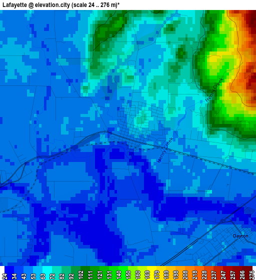
Below is the Elevation map of Lafayette, which displays elevation range with different colors. Scale of the first map is from 24 to 276 m (79 to 906 ft) with average elevation of 63 meters (=207 ft) [note 1]
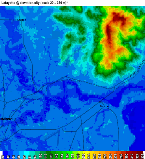
These maps also provides idea of topography and contour of this city, they are displayed at different zoom levels. More info about maps, scale and edge coordinates you can find below images.
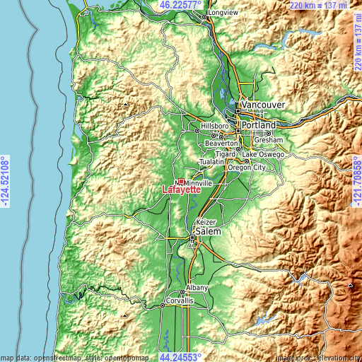
| \ | Map #1 | Map #2 | Topo.Map |
| Scale [m] | 24..276 m | 20..336 m | × |
| Scale [ft] | 79..906 ft | 66..1102 ft | × |
| Average | 63 m = 207 ft | 71.3 m = 234 ft | × |
| Width | 6.88 km = 4.3 mi | 13.76 km = 8.6 mi | 220.2 km = 136.8 mi |
| Height | 6.88 km = 4.3 mi | 13.76 km = 8.6 mi | 220.2 km = 136.8 mi |
| ↑Max Latitude | 45.275213° | 45.306129° | 46.22577° |
| Latitude at center | 45.24428° | 45.24428° | 45.24428° |
| ↓Min Latitude | 45.21333° | 45.182364° | 44.24553° |
| ← Min Longitude | -123.158775° | -123.202721° | -124.52108° |
| Longitude center | -123.11483° | -123.11483° | -123.11483° |
| →Max Longitude | -123.070885° | -123.026939° | -121.70858° |
Nearby cities:
Cities around Lafayette sort by population:
• McMinnville elevation 48 m
7.6 km,  239°
239°
• Woodburn 59 m
23.2 km,  118°
118°
• Newberg 56 m
12.7 km,  60°
60°
• Sherwood 60 m
24.8 km, 59°
• Hubbard 55 m
25 km,  105°
105°
• Dundee 66 m
9 km,  65°
65°
• Gervais 56 m
22.8 km,  131°
131°
• Dayton 51 m
4 km, 130°
• Carlton 62 m
7.4 km,  319°
319°
• Amity 56 m
16 km,  206°
206°
• Yamhill 60 m
12.2 km,  332°
332°
• Donald 59 m
21.7 km,  96°
96°
Multilingual:
 En español:
Lafayette elevación 52 m.
 En France:
Lafayette élévation 52 m.
 Auf Deutsch:
Lafayette höhe über dem Meeresspiegel ist 52 m.

Sources and notes:
- [note 1] Map square and city borders are not equal. Map elevation data is calculated only from area inside that square.
- [src 1] Elevation data from geonames database provided with same terms of usage.
- [src 2] The elevation map of Lafayette is generated using elevation data from NASA's 3 arcsec (90m) resolution SRTM data.
- [src 3] Base (background) map © OpenStreetMap contributors tiles are generated by Geofabrik and OpenTopoMap.
Copyright & License:
This Lafayette Elevation Map is licensed under CC BY-SA. You may reuse any part from this page, if you give a proper credit by linking to this URL:
 More info on terms of use page.