Grand Ronde elevation
Grand Ronde (Oregon, Polk County), United States elevation is 105 meters and Grand Ronde elevation in feet is 344 ft above sea level [src 1]. Grand Ronde is a populated place (feature code) with elevation that is 174 meters (571 ft) smaller than average city elevation in United States.
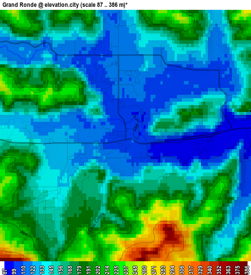
Below is the Elevation map of Grand Ronde, which displays elevation range with different colors. Scale of the first map is from 87 to 386 m (285 to 1266 ft) with average elevation of 159.7 meters (=524 ft) [note 1]
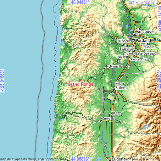
These maps also provides idea of topography and contour of this city, they are displayed at different zoom levels. More info about maps, scale and edge coordinates you can find below images.
| \ | Map #1 | Topo.Map |
| Scale [m] | 87..386 m | × |
| Scale [ft] | 285..1266 ft | × |
| Average | 159.7 m = 524 ft | × |
| Width | 6.9 km = 4.3 mi | 220.9 km = 137.3 mi |
| Height | 6.9 km = 4.3 mi | 220.9 km = 137.3 mi |
| ↑Max Latitude | 45.091143° | 46.04481° |
| Latitude at center | 45.06011° | 45.06011° |
| ↓Min Latitude | 45.02906° | 44.05816° |
| ← Min Longitude | -123.653225° | -125.01553° |
| Longitude center | -123.60928° | -123.60928° |
| →Max Longitude | -123.565335° | -122.20303° |
Nearby cities:
Cities around Grand Ronde sort by population:
• McMinnville elevation 48 m
36.3 km,  62°
62°
• Dallas 101 m
27.8 km,  124°
124°
• Monmouth 63 m
37.8 km,  128°
128°
• Independence 52 m
40.6 km, 124°
• Lincoln City 32 m
34.1 km,  250°
250°
• Sheridan 56 m
17.4 km,  75°
75°
• Willamina 70 m
9.9 km, 77°
• Carlton 62 m
42.8 km,  52°
52°
• Lincoln Beach 16 m
41.6 km,  235°
235°
• Rose Lodge 62 m
22 km,  255°
255°
• Amity 56 m
32.2 km, 78°
• Pacific City 1 m
31.9 km,  299°
299°
Multilingual:
 En español:
Grand Ronde elevación 105 m.
 En France:
Grand Ronde élévation 105 m.
 Auf Deutsch:
Grand Ronde höhe über dem Meeresspiegel ist 105 m.

Sources and notes:
- [note 1] Map square and city borders are not equal. Map elevation data is calculated only from area inside that square.
- [src 1] Elevation data from geonames database provided with same terms of usage.
- [src 2] The elevation map of Grand Ronde is generated using elevation data from NASA's 3 arcsec (90m) resolution SRTM data.
- [src 3] Base (background) map © OpenStreetMap contributors tiles are generated by Geofabrik and OpenTopoMap.
Copyright & License:
This Grand Ronde Elevation Map is licensed under CC BY-SA. You may reuse any part from this page, if you give a proper credit by linking to this URL:
 More info on terms of use page.