John Day elevation
John Day (Oregon, Grant County), United States elevation is 941 meters and John Day elevation in feet is 3087 ft above sea level [src 1]. John Day is a populated place (feature code) with elevation that is 662 meters (2172 ft) bigger than average city elevation in United States.
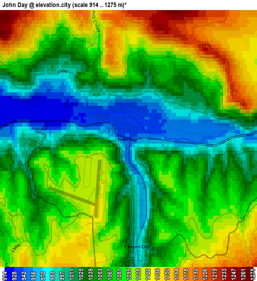
Below is the Elevation map of John Day, which displays elevation range with different colors. Scale of the first map is from 914 to 1275 m (2999 to 4183 ft) with average elevation of 1067.3 meters (=3502 ft) [note 1]
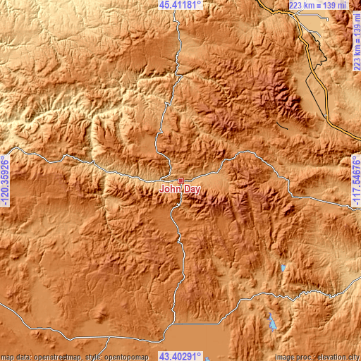
These maps also provides idea of topography and contour of this city, they are displayed at different zoom levels. More info about maps, scale and edge coordinates you can find below images.
| \ | Map #1 | Topo.Map |
| Scale [m] | 914..1275 m | × |
| Scale [ft] | 2999..4183 ft | × |
| Average | 1067.3 m = 3502 ft | × |
| Width | 6.98 km = 4.3 mi | 223.4 km = 138.8 mi |
| Height | 6.98 km = 4.3 mi | 223.4 km = 138.8 mi |
| ↑Max Latitude | 44.447371° | 45.41181° |
| Latitude at center | 44.41599° | 44.41599° |
| ↓Min Latitude | 44.384592° | 43.40291° |
| ← Min Longitude | -118.996955° | -120.35926° |
| Longitude center | -118.95301° | -118.95301° |
| →Max Longitude | -118.909065° | -117.54676° |
Nearby cities:
Cities around John Day sort by population:
• Pendleton elevation 327 m
140.3 km,  5°
5°
• La Grande 844 m
121.9 km,  34°
34°
• Baker City 1053 m
97.1 km,  65°
65°
• Burns 1265 m
92.6 km,  185°
185°
• Union 849 m
123 km,  44°
44°
• Hines 1265 m
95.3 km, 186°
• Pilot Rock 521 m
119.1 km,  4°
4°
• Heppner 656 m
114.6 km,  335°
335°
• Island City 833 m
125.3 km, 34°
• Condon 861 m
133.1 km,  313°
313°
• Canyon City 974 m
2.9 km,  175°
175°
• Fossil 806 m
119 km,  302°
302°
Multilingual:
 En español:
John Day elevación 941 m.
 En France:
John Day élévation 941 m.
 Auf Deutsch:
John Day höhe über dem Meeresspiegel ist 941 m.

Sources and notes:
- [note 1] Map square and city borders are not equal. Map elevation data is calculated only from area inside that square.
- [src 1] Elevation data from geonames database provided with same terms of usage.
- [src 2] The elevation map of John Day is generated using elevation data from NASA's 3 arcsec (90m) resolution SRTM data.
- [src 3] Base (background) map © OpenStreetMap contributors tiles are generated by Geofabrik and OpenTopoMap.
Copyright & License:
This John Day Elevation Map is licensed under CC BY-SA. You may reuse any part from this page, if you give a proper credit by linking to this URL:
 More info on terms of use page.