Fossil elevation
Fossil (Oregon, Wheeler County), United States elevation is 806 meters and Fossil elevation in feet is 2644 ft above sea level [src 1]. Fossil is a seat of a second-order administrative division (feature code) with elevation that is 527 meters (1729 ft) bigger than average city elevation in United States.
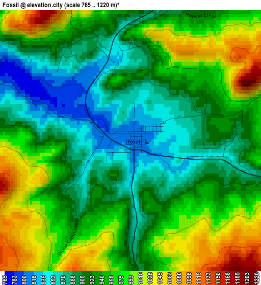
Below is the Elevation map of Fossil, which displays elevation range with different colors. Scale of the first map is from 765 to 1220 m (2510 to 4003 ft) with average elevation of 941.1 meters (=3088 ft) [note 1]
These maps also provides idea of topography and contour of this city, they are displayed at different zoom levels. More info about maps, scale and edge coordinates you can find below images.
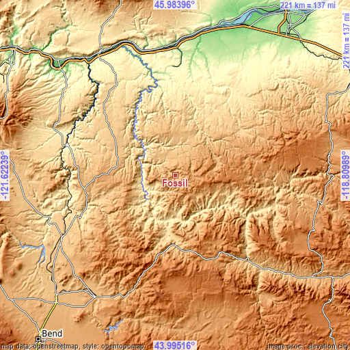
| \ | Map #1 | Topo.Map |
| Scale [m] | 765..1220 m | × |
| Scale [ft] | 2510..4003 ft | × |
| Average | 941.1 m = 3088 ft | × |
| Width | 6.91 km = 4.3 mi | 221.1 km = 137.4 mi |
| Height | 6.91 km = 4.3 mi | 221.1 km = 137.4 mi |
| ↑Max Latitude | 45.029257° | 45.98396° |
| Latitude at center | 44.99819° | 44.99819° |
| ↓Min Latitude | 44.967107° | 43.99516° |
| ← Min Longitude | -120.260085° | -121.62239° |
| Longitude center | -120.21614° | -120.21614° |
| →Max Longitude | -120.172195° | -118.80989° |
Nearby cities:
Cities around Fossil sort by population:
• The Dalles elevation 81 m
100.3 km,  311°
311°
• Prineville 878 m
91.8 km,  212°
212°
• Madras 685 m
82.7 km,  240°
240°
• Goldendale 497 m
102.9 km,  332°
332°
• Boardman 94 m
101.9 km,  23°
23°
• Warm Springs 466 m
86.7 km,  252°
252°
• Culver 802 m
94.6 km, 236°
• Heppner 656 m
65 km,  52°
52°
• Terrebonne 873 m
104.5 km,  226°
226°
• Dallesport 65 m
102.1 km, 312°
• Condon 861 m
26.4 km,  5°
5°
• Moro 553 m
67.4 km,  323°
323°
Multilingual:
 En español:
Fossil elevación 806 m.
 En France:
Fossil élévation 806 m.


Sources and notes:
- [note 1] Map square and city borders are not equal. Map elevation data is calculated only from area inside that square.
- [src 1] Elevation data from geonames database provided with same terms of usage.
- [src 2] The elevation map of Fossil is generated using elevation data from NASA's 3 arcsec (90m) resolution SRTM data.
- [src 3] Base (background) map © OpenStreetMap contributors tiles are generated by Geofabrik and OpenTopoMap.
Copyright & License:
This Fossil Elevation Map is licensed under CC BY-SA. You may reuse any part from this page, if you give a proper credit by linking to this URL:
 More info on terms of use page.