The Dalles elevation
The Dalles (Oregon, Wasco County), United States elevation is 81 meters and The Dalles elevation in feet is 266 ft above sea level [src 1]. The Dalles is a seat of a second-order administrative division (feature code) with elevation that is 198 meters (650 ft) smaller than average city elevation in United States.
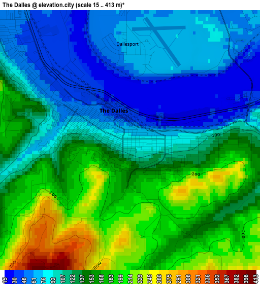
Below is the Elevation map of The Dalles, which displays elevation range with different colors. Scale of the first map is from 15 to 413 m (49 to 1355 ft) with average elevation of 129.7 meters (=426 ft) [note 1]
These maps also provides idea of topography and contour of this city, they are displayed at different zoom levels. More info about maps, scale and edge coordinates you can find below images.
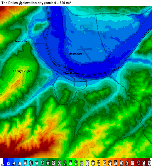
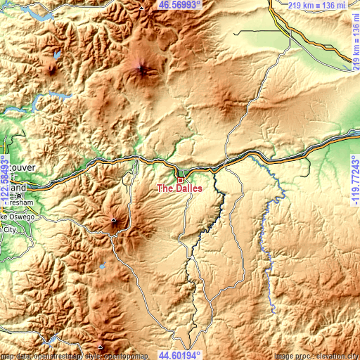
| \ | Map #1 | Map #2 | Topo.Map |
| Scale [m] | 15..413 m | 9..626 m | × |
| Scale [ft] | 49..1355 ft | 30..2054 ft | × |
| Average | 129.7 m = 426 ft | 204.1 m = 670 ft | × |
| Width | 6.84 km = 4.3 mi | 13.68 km = 8.5 mi | 218.8 km = 136 mi |
| Height | 6.84 km = 4.3 mi | 13.68 km = 8.5 mi | 218.8 km = 136 mi |
| ↑Max Latitude | 45.625301° | 45.656026° | 46.56993° |
| Latitude at center | 45.59456° | 45.59456° | 45.59456° |
| ↓Min Latitude | 45.563802° | 45.533026° | 44.60194° |
| ← Min Longitude | -121.222625° | -121.266571° | -122.58493° |
| Longitude center | -121.17868° | -121.17868° | -121.17868° |
| →Max Longitude | -121.134735° | -121.090789° | -119.77243° |
Nearby cities:
Cities around The Dalles sort by population:
• Sandy elevation 296 m
87.2 km,  255°
255°
• Hood River 138 m
29.4 km,  294°
294°
• Mount Hood Village 393 m
67.9 km,  246°
246°
• Goldendale 497 m
37.4 km,  47°
47°
• White Salmon 186 m
28.1 km,  301°
301°
• Carson 141 m
51.9 km, 286°
• Odell 219 m
28.6 km,  277°
277°
• Chenoweth 131 m
6.2 km,  306°
306°
• Stevenson 63 m
56 km, 281°
• Dallesport 65 m
2.5 km,  358°
358°
• Cascade Locks 40 m
56 km, 278°
• Moro 553 m
37 km,  109°
109°
Multilingual:
 En español:
The Dalles elevación 81 m.
 En France:
The Dalles élévation 81 m.
 Auf Deutsch:
The Dalles höhe über dem Meeresspiegel ist 81 m.

Sources and notes:
- [note 1] Map square and city borders are not equal. Map elevation data is calculated only from area inside that square.
- [src 1] Elevation data from geonames database provided with same terms of usage.
- [src 2] The elevation map of The Dalles is generated using elevation data from NASA's 3 arcsec (90m) resolution SRTM data.
- [src 3] Base (background) map © OpenStreetMap contributors tiles are generated by Geofabrik and OpenTopoMap.
Copyright & License:
This The Dalles Elevation Map is licensed under CC BY-SA. You may reuse any part from this page, if you give a proper credit by linking to this URL:
 More info on terms of use page.