Carson elevation
Carson (Washington, Skamania County), United States elevation is 141 meters and Carson elevation in feet is 463 ft above sea level [src 1]. Carson is a populated place (feature code) with elevation that is 138 meters (453 ft) smaller than average city elevation in United States.
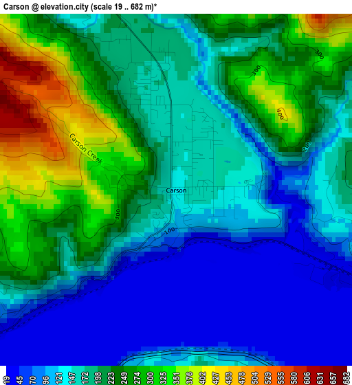
Below is the Elevation map of Carson, which displays elevation range with different colors. Scale of the first map is from 19 to 682 m (62 to 2238 ft) with average elevation of 184.4 meters (=605 ft) [note 1]
These maps also provides idea of topography and contour of this city, they are displayed at different zoom levels. More info about maps, scale and edge coordinates you can find below images.
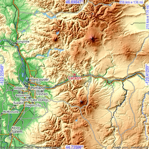
| \ | Map #1 | Topo.Map |
| Scale [m] | 19..682 m | × |
| Scale [ft] | 62..2238 ft | × |
| Average | 184.4 m = 605 ft | × |
| Width | 6.82 km = 4.2 mi | 218.3 km = 135.6 mi |
| Height | 6.82 km = 4.2 mi | 218.3 km = 135.6 mi |
| ↑Max Latitude | 45.75606° | 46.69847° |
| Latitude at center | 45.72539° | 45.72539° |
| ↓Min Latitude | 45.694703° | 44.73506° |
| ← Min Longitude | -121.863185° | -123.22549° |
| Longitude center | -121.81924° | -121.81924° |
| →Max Longitude | -121.775295° | -120.41299° |
Nearby cities:
Cities around Carson sort by population:
• Camas elevation 23 m
47.6 km,  251°
251°
• Washougal 25 m
44.4 km, 249°
• Hood River 138 m
23.2 km,  95°
95°
• Mount Hood Village 393 m
43 km,  196°
196°
• Venersborg 169 m
47.3 km,  276°
276°
• White Salmon 186 m
25.8 km,  89°
89°
• Odell 219 m
24.1 km,  117°
117°
• Fern Prairie 143 m
46.1 km,  257°
257°
• Chenoweth 131 m
46 km, 103°
• Yacolt 217 m
48.1 km,  288°
288°
• Stevenson 63 m
6.1 km,  236°
236°
• Cascade Locks 40 m
8.3 km,  221°
221°
Multilingual:
 En español:
Carson elevación 141 m.
 En France:
Carson élévation 141 m.


Sources and notes:
- [note 1] Map square and city borders are not equal. Map elevation data is calculated only from area inside that square.
- [src 1] Elevation data from geonames database provided with same terms of usage.
- [src 2] The elevation map of Carson is generated using elevation data from NASA's 3 arcsec (90m) resolution SRTM data.
- [src 3] Base (background) map © OpenStreetMap contributors tiles are generated by Geofabrik and OpenTopoMap.
Copyright & License:
This Carson Elevation Map is licensed under CC BY-SA. You may reuse any part from this page, if you give a proper credit by linking to this URL:
 More info on terms of use page.