Mount Hood Village elevation
Mount Hood Village (Oregon, Clackamas County), United States elevation is 393 meters and Mount Hood Village elevation in feet is 1289 ft above sea level [src 1]. Mount Hood Village is a populated place (feature code) with elevation that is 114 meters (374 ft) bigger than average city elevation in United States.
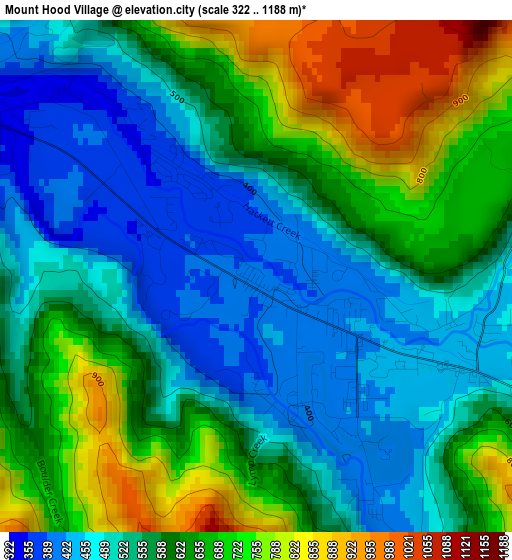
Below is the Elevation map of Mount Hood Village, which displays elevation range with different colors. Scale of the first map is from 322 to 1188 m (1056 to 3898 ft) with average elevation of 592.6 meters (=1944 ft) [note 1]
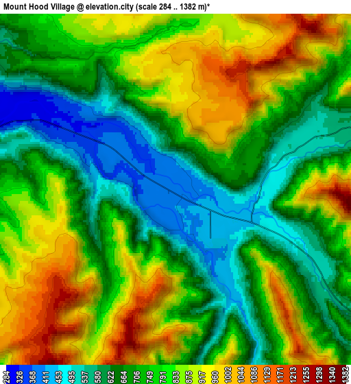
These maps also provides idea of topography and contour of this city, they are displayed at different zoom levels. More info about maps, scale and edge coordinates you can find below images.
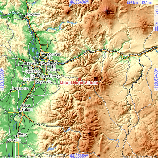
| \ | Map #1 | Map #2 | Topo.Map |
| Scale [m] | 322..1188 m | 284..1382 m | × |
| Scale [ft] | 1056..3898 ft | 932..4534 ft | × |
| Average | 592.6 m = 1944 ft | 762.2 m = 2501 ft | × |
| Width | 6.87 km = 4.3 mi | 13.73 km = 8.5 mi | 219.8 km = 136.6 mi |
| Height | 6.87 km = 4.3 mi | 13.73 km = 8.5 mi | 219.7 km = 136.5 mi |
| ↑Max Latitude | 45.386272° | 45.417128° | 46.33496° |
| Latitude at center | 45.3554° | 45.3554° | 45.3554° |
| ↓Min Latitude | 45.324511° | 45.293605° | 44.35859° |
| ← Min Longitude | -122.024585° | -122.068531° | -123.38689° |
| Longitude center | -121.98064° | -121.98064° | -121.98064° |
| →Max Longitude | -121.936695° | -121.892749° | -120.57439° |
Nearby cities:
Cities around Mount Hood Village sort by population:
• Gresham elevation 96 m
38.6 km,  294°
294°
• Camas 23 m
41.6 km,  308°
308°
• Troutdale 39 m
37.7 km,  302°
302°
• Washougal 25 m
38.5 km, 310°
• Damascus 162 m
38 km,  280°
280°
• Sandy 296 m
22.4 km, 282°
• Fairview 42 m
40.8 km, 299°
• Wood Village 48 m
39.5 km, 300°
• Estacada 158 m
28.6 km,  255°
255°
• Carson 141 m
43 km,  16°
16°
• Stevenson 63 m
38.6 km,  11°
11°
• Cascade Locks 40 m
35.7 km, 11°
Multilingual:
 En español:
Mount Hood Village elevación 393 m.
 En France:
Mount Hood Village élévation 393 m.
 Auf Deutsch:
Mount Hood Village höhe über dem Meeresspiegel ist 393 m.
 На русском:
Mount Hood Village высота над уровнем моря 393 м
Sources and notes:
- [note 1] Map square and city borders are not equal. Map elevation data is calculated only from area inside that square.
- [src 1] Elevation data from geonames database provided with same terms of usage.
- [src 2] The elevation map of Mount Hood Village is generated using elevation data from NASA's 3 arcsec (90m) resolution SRTM data.
- [src 3] Base (background) map © OpenStreetMap contributors tiles are generated by Geofabrik and OpenTopoMap.
Copyright & License:
This Mount Hood Village Elevation Map is licensed under CC BY-SA. You may reuse any part from this page, if you give a proper credit by linking to this URL:
 More info on terms of use page.